Dover, Massachusetts
| Dover | |||
| Kommun (town) | |||
| |||
| Land | |||
|---|---|---|---|
| Delstat | |||
| County | Norfolk County | ||
| Höjdläge | 46 m ö.h. | ||
| Koordinater | 42°14′45″N 71°17′0″V / 42.24583°N 71.28333°V | ||
| Area | 39,89 km² | ||
| Folkmängd | 5 923 (2020)[2] | ||
| Befolkningstäthet | 148 invånare/km² | ||
| Grundad | 1635[1] | ||
| Tidszon | EST (UTC-5) | ||
| - sommartid | EDT (UTC-4) | ||
| ZIP-kod | 02030 | ||
| GNIS-kod | 618319 | ||
| Geonames | 4935010 | ||
Översiktskarta | |||
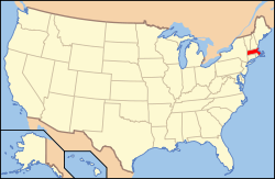
Massachusetts läge i USA | |||
| Wikimedia Commons: Dover, Massachusetts | |||
| Webbplats: http://www.doverma.org/ | |||
| Redigera Wikidata | |||
Dover är en kommun i Norfolk County i delstaten Massachusetts, USA.
Referenser
- ^ hämtat från: franskspråkiga Wikipedia.[källa från Wikidata]
- ^ United States Census Bureau (red.), USA:s folkräkning 2020, läs online, läst: 1 januari 2022.[källa från Wikidata]
Media som används på denna webbplats
Seal of the Town of Dover, Massachusetts: The Seal was "established at a meeting called for that purpose" on 4-30-1894. Upon a field showing on the dexter side a schoolhouse and brook and on the sinister side a hill and Indians, an escutcheon bearing azure on a mount vert, a meetinghouse, without steeple, proper, crest, a plow and garb crosswise, proper, motto "Incorporated 1836," surrounded by a circle inscribed in chief "Town of Dover," and in base, "Massachusetts," divided on the dexter side by "Parish 1748" and the sinister side by "District 1784."
Författare/Upphovsman: John Phelan, Licens: CC BY-SA 3.0
The Dover Church, Dover Massachusetts
Flag of Dover, Massachusetts. Unkno
Författare/Upphovsman: This version: uploader
Base versions this one is derived from: originally created by en:User:Wapcaplet, Licens: CC BY 2.0
Map of USA with Massachusetts highlighted
Författare/Upphovsman: VulcanTrekkie45, Licens: CC BY-SA 3.0
Location of Dover in Norfolk County, Massachusetts


