Dorchester, Massachusetts
| Dorchester | ||
| Land | ||
|---|---|---|
| Delstat | ||
| County | Suffolk County | |
| Stad | Boston | |
| Koordinater | 42°19′0″N 71°3′0″V / 42.31667°N 71.05000°V | |
| Grundad | maj 1630[1] | |
| Tidszon | EST (UTC-5) | |
| - sommartid | EDT (UTC-4) | |
| GNIS-kod | 612904 | |
| Geonames | 4934964 | |
Ortens läge i delstaten | ||
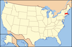
Massachusetts läge i USA | ||
| Wikimedia Commons: Dorchester, Boston | ||
| Webbplats: http://www.mydorchester.org/ | ||
| Redigera Wikidata | ||
Dorchester är en stadsdel i Boston i delstaten Massachusetts, USA. Den grundades 1630 av puritaner från Dorchester i England. År 1870 blev Dorchester en del av staden Boston.
Referenser
- ^ hämtat från: engelskspråkiga Wikipedia.[källa från Wikidata]
Media som används på denna webbplats
Shiny red button/marker widget. Used to mark the location of something such as a tourist attraction.
Författare/Upphovsman: Alexrk2, Licens: CC BY 3.0
Location map of Massachusetts, USA
Lower Mills Village, Massachusetts, spanning both sides of the Neponset River between Milton (on the right) and City of Boston (Dorchester) (on the left). These buildings were once part of the Walter Baker Chocolate Factory.
Författare/Upphovsman: This version: uploader
Base versions this one is derived from: originally created by en:User:Wapcaplet, Licens: CC BY 2.0
Map of USA with Massachusetts highlighted
Seal of Dorchester, Massachusetts


