Dinan
| Dinan | ||
| Kommun | ||
 Slottet i Dinan | ||
| ||
| Land | ||
|---|---|---|
| Region | ||
| Departement | ||
| Arrondissement | Dinan | |
| Kanton | chef-lieu för Dinan-Est och Dinan-Ouest | |
| Koordinater | 48°27′N 2°14′V / 48.450°N 2.233°V | |
| Yta | 8,7 km²[1] | |
| Folkmängd | 14 675 ()[2] | |
| Befolkningstäthet | 1 687 invånare/km² | |
| Tidszon | CET (UTC+1) | |
| - sommartid | CEST (UTC+2) | |
| Postnummer | 22100 | |
| INSEE | 22050 | |
| Geonames | 6614300 | |
| OSM-karta | 7858571 | |
 Kommunens läge i regionen Bretagne i Frankrike | ||
| Webbplats: http://www.mairie-dinan.com/ Officiell webbplats | ||
.svg)

Dinan är en kommun i departementet Côtes-d'Armor i regionen Bretagne i nordvästra Frankrike. Kommunen är chef-lieu för Dinan-Est och Dinan-Ouest och även för arrondissementet Dinan. År 2021 hade Dinan 14 675 invånare.
Befolkningsutveckling
Antalet invånare i kommunen Dinan
Referens:INSEE[3]
Galleri

 Motte castrale (låglandborg) på Bayeuxtapeten
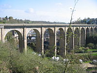
Se även
Källor
- ^ Répertoire géographique des communes, Institut national de l'information géographique et forestière, läst: 26 oktober 2015, licens: öppen licens.[källa från Wikidata]
- ^ Populations légales 2021, Institut National de la Statistique et des Études Économiques, 28 december 2023.[källa från Wikidata]
- ^ Chiffres clés - Évolution et structure de la population Arkiverad 5 juli 2012 hämtat från the Wayback Machine.
Externa länkar
- Officiell webbplats
 Wikimedia Commons har media som rör Dinan.
Media som används på denna webbplats

Författare/Upphovsman: Eric Gaba (Sting - fr:Sting), Licens: CC BY-SA 4.0
Blank physical map of metropolitan France for geo-location purpose.
Scale : 1:14 816 000 (accuracy : about 3,7 km) for the bathymetry. More maps of France, view → Commons Atlas of France.

Shiny red button/marker widget. Used to mark the location of something such as a tourist attraction.


Författare/Upphovsman: Olivier2000, Licens: CC BY-SA 1.0
Viaduc de Dinan (Côtes d'Armor, France) sur la Rance

Författare/Upphovsman:
|
Map data (c) OpenStreetMap contributors, CC-BY-SA _French_municipality_map.svg) • Shape files infrastructure: railway, highways, water: all originally by OpenStreetMap contributors. Status december 2011 *note: shown commune boundaries are from OSM dump May 2012; at that time about 90% complete |
Map commune FR insee code 22050.png

Bayeux Tapestry - Scene 19: siege of Dinan (detail). The soldiers of William, Duke of Normandy attack the motte-and-bailey castle of Dinan. Conan II, Duke of Brittany surrenders and gives the keys to Dinan via a lance.
