Decapolis
| Decapolis | |
| Stadsförbund | |
 Lägeskarta över Decapolis städer | |
| Region | Mellanöstern |
|---|---|

Decapolis (grekiska Δεκάπολις efter deca - tio och polis - stad[1]) är beteckningen för ett historiskt[2] stadsförbund[3] om tio hellenistiska[4]-romerska städer i Mellanöstern.[5] Huvuddelen av städerna finns i Jordanien och några finns dessutom i Israel och Syrien. Flera av stadsområdena är upptagen på Unescos tentativa Världsarvslista.
Städerna
Städerna låg i de historiska områdena Judeen och Galileen i den sydöstra delen av Levanten. Decapolis ligger geografiskt samlad[5] öster och söder om Gennesaretsjön[1] förutom staden Damaskus som en del historiker[2] anser[3] endast var en hedersmedlem. Varje stad[4] var ett fristatsområde[3][5] med kringliggande landsbygd,[2] byar och gårdar. Städerna kontrollerade handeln i området.
De flesta stadsområdena är idag ruiner[1] som ligger inom moderna städer. Abila, Gadara, Pella i Jordanien och Scythopolis i Israel är upptagen på Unescos lista över tentativa världsarv.
Decapolis omfattade:[5]
| stad | land | alternativt namn | läge |
|---|---|---|---|
| Capitolias | Jordanien | Adun, Dion | Beit Ras, 100 km nordväst om Amman |
| Damascu | Syrien | Damascus | Damaskus, 200 km nordöst om Amman |
| Gadara | Jordanien | Gad'a-ra | Umm Qais, 110 km nordväst om Amman |
| Gerasa | Jordanien | Garshu | Jarash, 45 km norr om Amman |
| Hippos | Israel | Susieh, Qal'at al-Husn | Sussita, 110 km sydväst om Damaskus |
| Kanatha | Syrien | Canatha | Qanawat, 100 km sydöst om Damaskus |
| Raphana | Jordanien | Abela, Abila, Raphon | Qweilbeh, 130 km norr om Amman |
| Scythopolis | Israel | Bīsān | Bet She'an, 105 km nordväst om Amman |
| Pella | Jordanien | Fihil | Tabagat Fahl, 90 km nordväst om Amman |
| Philadelphia | Jordanien | Rabbath-Ammon | Amman, 200 km sydväst om Damaskus |
 Capitolias / Adun
 Damascu / Damaskus
 Gadara / Umm Qais
 Gerasa / Jarash
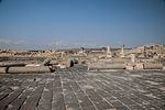 Hippos / Sussita
 (c) Gianfranco Gazzetti / GAR, CC BY-SA 4.0Kanatha / Qanawat
 Raphana / Qweilbeh
 Scythopolis / Bet She'an
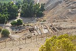 Pella / Tabagat Fahl
 Philadelphia / Amman
Historia
Decapolis omnämns[3] i tre böcker[1] i det Nya Testamentet[6] (Dekapolis Matteusevangeliet 4:25, Markusevangeliet 5:20 och 7:31 och Gerasenernas land Lukasevangeliet 8:26 och 8:37) och Plinius den äldre namnger[4] de tio städerna[5] i sitt verk Naturalis Historia[7] (Decapolitana, Liber V, kap IV, avsnitt 74, 77). Decapolis omnämns även[1] i skrifter[5] av Josephus (i Bellum Judaicum), Ptolemaeus (i Geographia) och Strabon (i Geographica).
Städerna byggdes med början i den hellenistiska perioden[4] och förstärktes[4] under den romerske fältherren Pompejus[2] kring år 63[3] f Kr[1] som del i det östra Romarriket som försvarslinje av den östra gränsen.[2] Kring år 106[4] splittrades området under kejsare Trajanus[5] och införlivades i de romerska provinserna Arabia petraea och Syria.
Referenser
- ^ [a b c d e f] Decapolis Catholic Encyclopedia (läst 1 juli 2017)
- ^ [a b c d e] The Decapolis Arkiverad 5 februari 2005 hämtat från the Wayback Machine. BibArch (läst 1 juli 2017)
- ^ [a b c d e] The Decapolis Atlas Tours (läst 1 juli 2017)
- ^ [a b c d e f] Decapolis Livius.org (läst 1 juli 2017)
- ^ [a b c d e f g] The Decapolis of Jordan AramcoWorld (läst 1 juli 2017)
- ^ Decapolis Bible Gateway (läst 12 juni 2017)
- ^ Naturalis Historia Wiki Source (läst 12 juni 2017)
Externa länkar
- om Decapolis (Encyclopædia Britannica)
- bilder Decapolis (Flickr)
- bilder Decapolis (Getty Images)
- filmer Decapolis (YouTube)
Media som används på denna webbplats
.jpg)
Författare/Upphovsman: Jerzy Strzelecki, Licens: CC BY-SA 3.0
roman theater in Amman, Jordan

Författare/Upphovsman: Bernard Gagnon, Licens: CC BY-SA 3.0
Ancient Roman triumphal arch (Al Kharab) on Street Called Straight, Damascus, Syria.

Författare/Upphovsman: Zachchan2015, Licens: CC BY-SA 4.0
Capitolias Theatre, 2004

Författare/Upphovsman: עמוס גל, Licens: CC BY-SA 4.0
This is a photo of a place that is recognized as a heritage site by the Council for Conservation of Heritage Sites in Israel.
The site's ID in Wiki Loves Monuments photographic competition is

Författare/Upphovsman: Jean Housen, Licens: CC BY 3.0
Pella (Tabaqat Fahil) : vue d'ensemble du site.
(c) Wikipedia User:Andrew c, CC BY 3.0
This is a map of first century Iudaea Province that I created using Illustrator CS2. I traced this image for the general geographic features. I then manually input data from maps found in a couple of sources.
- Robert W. Funk and the Jesus Seminar. The Acts of Jesus. HarperSanFrancisco: 1998. p. xxiv.
- Michael Grant. Jesus: An Historian's Review of the Gospels. Charles Scribner's Sons: 1977. p. 65-67.
- John P. Meier. A Marginal Jew. Doubleday: 1991. p. 1:434.
_ruins.jpg)
Författare/Upphovsman: Man77, Licens: CC BY-SA 3.0
Gadara/Umm Qais ruins
_(14595154277).jpg)
Identifier: dictionaryofbibl01scha Title: A dictionary of the Bible.. Year: 1887 (1880s) Authors: Schaff, Philip, 1819-1893 Subjects: Publisher: [n. p.]
View Book Page: Book Viewer
About This Book: Catalog Entry
View All Images: All Images From Book
Click here to view book online to see this illustration in context in a browseable online version of this book.
Text Appearing Before Image:
was as Deborah predicted. Sis-era fled, and died by the hand of Jael; his army was cut off and every manslain. Jud. 4: 21. The triumphal song composed or dic-tated by Deborah on that occasion is re-garded as one of the finest specimens ofOriental poetry. Jud. 5. We give a fewverses from a revised version : Lord, when thou wentest forth out of Seir,When thou marchedst out of the field of Edum,The earth trembled, the heavens also dropped,Yea, the clouds dropped water.The mountains flowed down at the presence of the Lord,Even that Sinai at the presence of the Lord the God of Israel. The kings came, they fought; Then fought the kings of Canaan In Taanach hy the waters of Megiddo; They took nogain of silver. They fought from heaven ; The stars from their courses fought against Sisera.The river Kishon swept them away,That ancient river, the river Kishon.March on, my soul, with strength.See Barak. Jael. DEBTOR. See Loan. DECAPOLIS (ten cities), a regionnoticed three times in the Bible. Matt.
Text Appearing After Image: Map of Decapolis. (Frovi Schaffs New Testament Commentary.) 4:25; Mark 5: 20 ; 7:31. It lay near I sides of the Jordan. The cities werethe Sea of Galilee, probably on both | rebuilt by the Romans about B. c. 65;226 DEC DEM but as other cities grew up, writers arenot agreed as to the Dames of the tencities. Pliny gives them as follows:Scythopolis, Hippos, Gadara, Pella,Philadelphia, Geiasa, Dion, Canatha,Raphana, Damascus. Six are deserted,and none have many inhabitants exceptDamascus. DECISION, VALLEY OF.Joel 3:14. See Jehoshaphat. DEDAS (lowyronnd). 1. The nameof a descendant of Ham. Gen. 10 : 7 ;1 Chr. 1: 9. 2. A son of Jokshan, son of Abra-ham by Keturah. Gen. 25 : 3 ; 1 Chr.1:32. DEDICATE, DEDICATION,a religious ceremony by which any per-son, place, or thing is set apart for theservice of God or to some sacred use.Num. 7; 2 Sam. 8 : 11: 1 Kgs. 8. Cities,walls, gates, and private houses werethus dedicated. Neh. 12 : 27. The prac-tice of consecration was very commonamong the Jews, a
Note About Images
Författare/Upphovsman: Nichalp, Licens: CC BY-SA 2.5
Avbildad plats: Decapolis

(c) Gianfranco Gazzetti / GAR, CC BY-SA 4.0
Temple of Rabbos, Al Quanawat in 2008

Författare/Upphovsman: Freedom's Falcon, Licens: CC BY-SA 3.0
This is a photo of a monument in Jordan identified by the ID
.jpg)
Författare/Upphovsman: Dan Lundberg, Licens: CC BY-SA 2.0
Roman ruins in Beit Shean—columns and fancy floor.
On Google Earth:
32°30'7.88"N, 35°30'6.78"E