Dawn (rymdsond)
 Dawn med Vesta och Ceres i bakgrunden | |
| Status | Avslutad |
|---|---|
| Typ | Kretsare |
| Program | Discoveryprogrammet |
| Organisation | NASA |
| Större entreprenör | Orbital Sciences, JPL, UCLA |
| NSSDC-ID | 2007-043A[1] |
| Uppdragets varaktighet | 16 år, 11 månader och 12 dagar (8 september 2024) >9 år (planerad) |
| Webbplats | Dawn Home |
| Uppskjutning | |
| Uppskjutningsplats | Cape Canaveral SLC-17B |
| Uppskjutning | 27 september 2007, 11:34 UTC |
| Uppskjutningsfarkost | Delta 7925H |
| Omloppsbana runt Vesta | |
| Gick in i bana | 16 juli 2011, 04:47 UTC |
| Excentricitet | ~cirkulär |
| Banlutning | Polär |
| Lämnade omloppsbanan | 5 september 2012, 06:26 UTC |
| Omloppsbana runt Ceres | |
| Gick in i bana | 6 mars 2015, 12:29 UTC |
| Förbiflygning av Mars | |
| Datum | 18 februari 2009, 00:27:58 UTC |
| Minsta avstånd | 542 km |
| Egenskaper | |
| Massa | 1 250 kg |
| Dimensioner | 1,64 × 19,7 × 1,77 m |
Dawn är en obemannad rymdsond som den 27 september 2007 klockan 13:34, svensk tid, lyfte från Cape Canaveral Air Force Station, Florida i USA. Sonden skulle undersöka de två tyngsta objekten i asteroidbältet, dvärgplaneten Ceres och asteroiden Vesta.
Sonden drivs med hjälp av en jonmotor som gör det möjligt att ändra rymdsondens bana och riktning under uppdragets gång utan att ha med sig stora mängder bränsle.
Uppdrag
Uppdragets mål är att undersöka solsystemets allra tidigaste epoker genom att studera två av de största asteroiderna i detalj. Ceres och Vesta har många egenskaper i kontrast med varandra som kan vara resultatet av att de bildats i två olika regioner av solsystemet. Ceres kan ha haft en "kall och blöt" tillkomst, som lämnat kvar vatten under dess yta. Däremot verkar Vesta ha haft en "het och torr" tillkomst som kan ha orsakat vulkanism.
Status
Efter raketuppskjutningen från Kennedy Space Center den 27 september 2007 och inledande kontroller av rymdfarkosten startades Dawns jonmotorer den 17 december. Omloppsbanan runt solen förstorades till den grad att den närmade sig planeten Mars, där en förbiflygning med gravitationsslunga gjordes i februari 2009. Under detta första interplanetariska stadium av resan var jonmotorerna igång 270 dygn, eller 85 procent av tiden. Dawn förbrukade endast 72 kilogram drivmedel (xenongas) för att uppnå en hastighetsändring på 1,81 km/s. Den 20 november 2008 gjorde Dawn sin första kursrättningsmanöver (engelska: Trajectory Correction Maneuver; TCM1) genom att aktivera jonmotor 1 i 2 timmar och 11 minuter. Ytterligare en kursrättningsmanöver var planerad i januari 2009, men efter Dawns konjunktion med solen bedömdes den onödig och utfördes aldrig.
Dawn kom närmast Mars den 17 februari 2009, då sonden flög 549 kilometer över Marsytan och genomförde en lyckad gravitationsslunga. Samtidigt försatte sig Dawn i säkerhetsläge, med dataförlust som följd. Två dagar senare var farkosten i normal drift igen. Orsaken till driftstoppet uppgavs vara ett mjukvarufel.
Resan fortsatte utåt och in i asteroidbältet. De första bilderna av Vesta släpptes 3 maj 2011, samtidigt som Dawn började närma sig asteroiden. Dawn nådde Vesta den 16 juli 2011. Rymdsonden planerades lämna asteroiden 26 augusti 2012, men på grund av försening lämnade rymdsonden asteroiden istället först 5 september, med en ny bana mot Ceres. I mars 2015 gick sonden in i omloppsbana runt Ceres.[2] och blev därmed först till en dvärgplanet, eftersom New Horizons som var på väg mot Pluto och dess månar inte nådde fram förrän i juli 2015.
Också Ceres ska studeras i ungefär ett års tid, tills styrraketernas bränsle tar slut. Därefter förväntas sonden bli kvar i omloppsbana runt Ceres, eftersom dess bana är stabil.[3][4]
Den 1 november 2018 förklaras uppdraget slutfört, efter att man förlorat kontakten med rymdsonden. Detta på grund av att bränslet tagit slut och att rymdsonden inte längre kunde rikta sina solpaneler mot solen.
Tidtabell över färden
- 27 september 2007 – Start
- 17 februari 2009 – Fick hjälp av Mars gravitation
- 16 juli 2011 – Kom fram till Vesta
- 5 september 2012 – Lämnade Vesta
- 6 mars 2015 – Kom fram till Ceres
- 30 juni 2016 – Uppdraget fullbordat
- 1 juli 2016 – Uppdraget förlängs
- 1 november 2018 – Uppdraget förklaras avslutat
Resultat från Vesta
Mätresultaten och fotografierna från studierna av Vesta analyseras fortfarande. Hittills har de bland annat resulterat i en detaljerad kartglob över asteroiden.
| Geologisk karta över Vesta baserad på information från Dawn[5] |
|---|
 |
Bildgalleri från Dawn besök vid Vesta
 Vesta från 265 000 kilometers avstånd
(14 juni 2011)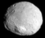 Vesta från 100 000 kilometers avstånd
(1 juli 2011)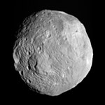 Vesta från 41 000 kilometers avstånd
(9 juli 2011) I omloppsbana på 16 000 kilometers avstånd
(17 juli 2011) I omloppsbana från 10 500 kilometers avstånd
(18 juli 2011)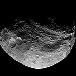 Norra hemisfären från 5 200 kilometers avstånd
(23 juli 2011)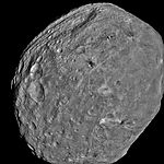 I omloppsbana från 5 200 kilometers avstånd
(24 juli 2011) I omloppsbana från 3 700 kilometers avstånd
(31 juli 2011)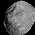 Full rotation
(1 augusti 2011) Terräng med kratrar och berg
(6 augusti 2011) Terräng med många kratrar i närheten av terminatorn
(6 augusti 2011)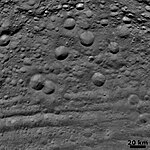
(6 augusti 2011)
Resultat från Ceres
Från och med januari 2015 kunde rymdsonden ta fotografier av dvärgplaneten med bättre upplösning än vad som är möjligt för Hubbleteleskopet. Under sina första omlopp runt Ceres, ungefär 22 dygn, planerades kartmaterial tas fram motsvarande den geologiska kartan över Vesta. I slutet av april 2015 närmade sig sonden sedan dvärgplaneten.[9] På grund av ett tekniskt fel fick dock antalet fotografier begränsas jämfört med planerna.
Bildgalleri från Ceres
 På 237 000 kilometers avstånd (25 januari 2015)
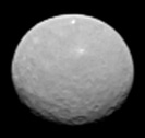 På 145 000 kilometers avstånd (4 februari 2015)
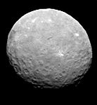 På 83 000 kilometers avstånd (12 februari 2015)
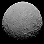 På 46 000 kilometers avstånd (19 februari 2015)
 På 22 000 kilometers avstånd (14 april 2015)
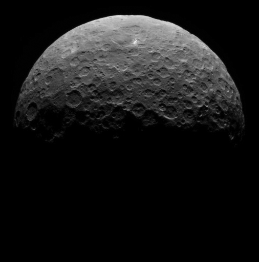
 På 13 500 kilometers avstånd (26 april 2015)
Se även
- Rosetta – rymdsonden som besökt en komet
Källor
Fotnoter
- ^ ”NASA Space Science Data Coordinated Archive” (på engelska). NASA. https://nssdc.gsfc.nasa.gov/nmc/spacecraft/display.action?id=2007-043A. Läst 31 mars 2020.
- ^ Elin Pärsson (6 mars 2015). ”Rymdsond har nått fram till dvärgplaneten Ceres”. Svenska dagbladet. http://www.svd.se/nyheter/utrikes/rymdsond-nar-fram-till-dvargplaneten-ceres_4387435.svd. Läst 10 mars 2015.
- ^ ”Dawn spacecraft gets an eyeful of dwarf planet Ceres” (på engelska). BBC. 19 januari 2015. http://www.bbc.com/news/science-environment-30888818. Läst 19 mars 2015.
- ^ Johan Warell. ”Dawn”. Nationalencyklopedin. Bokförlaget Bra böcker AB, Höganäs. http://www.ne.se/uppslagsverk/encyklopedi/l%C3%A5ng/dawn. Läst 19 mars 2015.
- ^ [a b] Williams, D. A.; Yingst, R. A.; Garry, W. B. (december 2014). ”Introduction: The geologic mapping of Vesta” (på engelska). Icarus 244: sid. 1–12. doi:. Läst 19 mars 2015.
- ^ Schäfer, M.; Nathues, A.; Williams, D. A.; Mittlefehldt, D. W.; Le Corre, L.; Buczkowski, D. L.; Kneissl, T.; Thangjam, G. S.; Hoffmann, M.; Schmedemann, N.; Schäfer, T.; Scully, J. E. C.; Li, J. Y.; Reddy, V.; Garry, W. B.; Krohn, K.; Yingst, R. A.; Gaskell, R. W.; Russell, C. T. (december 2014). ”Imprint of the Rheasilvia impact on Vesta – Geologic mapping of quadrangles Gegania and Lucaria” (på engelska). Icarus 244: sid. 60–73. doi:. Läst 19 mars 2015.
- ^ Schäfer, M.; Nathues, A.; Williams, D. A.; Mittlefehldt, D. W.; Le Corre, L.; Buczkowski, D. L.; Kneissl, T.; Thangjam, G. S.; Hoffmann, M.; Schmedemann, N.; Schäfer, T.; Scully, J. E. C.; Li, J. Y.; Reddy, V.; Garry, W. B.; Krohn, K.; Yingst, R. A.; Gaskell, R. W.; Russell, C. T. (december 2014). ”Imprint of the Rheasilvia impact on Vesta – Geologic mapping of quadrangles Gegania and Lucaria” (på engelska). Icarus 244: sid. 60–73. doi:. Läst 19 mars 2015.
- ^ Kneissl, T.; Schmedemann, N.; Reddy, V.; Williams, D. A.; Walter, S. H. G.; Neesemann, A.; Michael, G. G.; Jaumann, R.; Krohn, K.; Preusker, F.; Roatsch, T.; Le Corre, L.; Nathues, A.; Hoffmann, M.; Schäfer, M.; Buczkowski, D.; Garry, W. B.; Yingst, R. A.; Mest, S. C.; Russell, C. T.; Raymond, C. A. (december 2014). ”Morphology and formation ages of mid-sized post-Rheasilvia craters – Geology of quadrangle Tuccia, Vesta” (på engelska). Icarus 244: sid. 133–157. doi:. Läst 19 mars 2015.
- ^ Marc Rayman (29 januari 2015). ”Dawn blog” (på engelska). NASA. https://www.jpl.nasa.gov/blog/2015/1/more-than-just-a-pretty-picture-getting-the-view-on-ceres. Läst 19 mars 2015.
Externa länkar
 Wikimedia Commons har media som rör Dawn (rymdsond).
- Om Dawn på NASA:s webbplats
- Om Dawn på svenska
| ||||||||||||||||
Media som används på denna webbplats


PIA19064: Settling in at Ceres
http://photojournal.jpl.nasa.gov/catalog/PIA19064
http://www.jpl.nasa.gov/spaceimages/details.php?id=PIA19064
STILL IMAGE http://photojournal.jpl.nasa.gov/jpeg/PIA19064.jpg
ANIMATED IMAGE http://photojournal.jpl.nasa.gov/archive/PIA19064.gif
This animated sequence of images from NASA's Dawn spacecraft shows northern terrain on the sunlit side of dwarf planet Ceres. Dawn took these images on April 14 and 15 from a vantage point 14,000 miles (22,000 kilometers) above Ceres' northern hemisphere. The spacecraft was settling into its first circular orbit, called RC3 (for "rotation characterization 3"), which it will begin on April 23.
The bright feature called "spot 5" by the Dawn science team -- actually two bright spots close together -- rotates into view at right in the last few frames.
Dawn has now finished delivering the images that have helped mission planners maneuver the spacecraft to its first science orbit and prepare for subsequent observations.
Image scale on Ceres is about 1.3 miles (2.1 kilometers) per pixel, compared to 1.9 miles (3.1 kilometers) per pixel in the optical navigation images taken on April 10 (see PIA19064). The sun-Ceres-spacecraft angle, or phase angle is 91 degrees here, compared to 131 degrees in the previous sequence.
A processed still image from this sequence is also available.
http://photojournal.jpl.nasa.gov/jpeg/PIA19064.jpg
Dawn's mission is managed by JPL for NASA's Science Mission Directorate in Washington. Dawn is a project of the directorate's Discovery Program, managed by NASA's Marshall Space Flight Center in Huntsville, Alabama. UCLA is responsible for overall Dawn mission science. Orbital ATK, Inc., in Dulles, Virginia, designed and built the spacecraft. The German Aerospace Center, the Max Planck Institute for Solar System Research, the Italian Space Agency and the Italian National Astrophysical Institute are international partners on the mission team. For a complete list of acknowledgments, http://dawn.jpl.nasa.gov/mission.
An image of densely cratered terrain on Vesta near the terminator, taken by Dawn on August 6, 2011. It has a resolution of about 260 meters per pixel. North is in the direction of "two o'clock".

An image of craters in various states of degradation on Vesta, taken by Dawn on August 6, 2011. It has a resolution of about 260 meters per pixel.

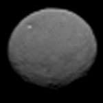
Ceres photographed by Dawn from about 80 000 km.

Image of Vesta obtained on July 31, 2011 by Dawn's framing camera from a distance of about 3,700 kilometers (2,300 miles). The smallest visible detail, which is about 2 pixels, corresponds to roughly 0.70 kilometers (0.43 miles).

A full rotation of the asteroid Vesta as seen from the Dawn spacecraft. Sixty-four images were extracted from the NASA video and animated. Vesta's actual rotation period is 5.342 hours.

Asteroid 4 Vesta from Dawn on July 17, 2011. The image was taken from a distance of 9,500 miles (15,000 km) away from Vesta.

This image by NASA's Dawn spacecraft shows the giant asteroid Vesta from a distance of 265.000 kilometres. Image credit: NASA/JPL-Caltech/UCLA/MPS/DLR/IDA


Cropped version of PIA19183. Rotated to place the south towards the bottom of the image.

The dark side of 4 Vesta imaged by the Dawn spacecraft from a distance of about 3,200 miles (5,200 km).
Geological Map of Vesta
November 17, 2014
http://www.jpl.nasa.gov/spaceimages/details.php?id=pia18788
http://www.jpl.nasa.gov/news/news.php?release=2014-399
This high-resolution geological map of Vesta is derived from Dawn spacecraft data. Brown colors represent the oldest, most heavily cratered surface. Purple colors in the north and light blue represent terrains modified by the Veneneia and Rheasilvia impacts, respectively. Light purples and dark blue colors below the equator represent the interior of the Rheasilvia and Veneneia basins. Greens and yellows represent relatively young landslides or other downhill movement and crater impact materials, respectively. This map unifies 15 individual quadrangle maps published this week in a special issue of Icarus. Map is a Mollweide projection, centered on 180 degrees longitude using the Dawn Claudia coordinate system.
JPL manages the Dawn mission for NASA's Science Mission Directorate in Washington. Dawn is a project of the directorate's Discovery Program, managed by NASA's Marshall Space Flight Center in Huntsville, Alabama. The University of California at Los Angeles (UCLA) is responsible for overall Dawn mission science. Orbital Sciences Corp. in Dulles, Virginia, designed and built the spacecraft. The German Aerospace Center, the Max Planck Institute for Solar System Research, the Italian Space Agency and the Italian National Astrophysical Institute are international partners on the mission team.
More information about Dawn is online at http://www.nasa.gov/dawn.
Vesta 4 as imaged by the Dawn spacecraft on July 18 (distance about 10,500 km)
The NASA insignia. Element RGB color values as defined in Encapsulated PostScript file obtained from the Publishing Office of NASA Glenn Research Center.

NASA's Dawn obtained this image with its framing camera on July 9, 2011. It was taken from a distance of about 26,000 miles (41,000 kilometers) away from the protoplanet Vesta. Each pixel in the image corresponds to roughly 2.4 miles (3.8 kilometers).

Images
February 4, 2015
Ceres on Approach
http://www.jpl.nasa.gov/spaceimages/details.php?id=pia19179
This image is one several images NASA's Dawn spacecraft took on approach to Ceres on Feb. 4, 2015 at a distance of about 90,000 miles (145,000 kilometers) from the dwarf planet. This image is one several images NASA's Dawn spacecraft took on approach to Ceres on Feb. 4, 2015 at a distance of about 90,000 miles (145,000 kilometers) from the dwarf planet. This series of images is the sharpest to date, at a resolution of 8.5 miles (14 kilometers) per pixel.
Dawn's mission to Vesta and Ceres is managed by the Jet Propulsion Laboratory for NASA's Science Mission Directorate in Washington. Dawn is a project of the directorate's Discovery Program, managed by NASA's Marshall Space Flight Center in Huntsville, Alabama. UCLA is responsible for overall Dawn mission science. Orbital Sciences Corp. of Dulles, Virginia, designed and built the spacecraft. JPL is managed for NASA by the California Institute of Technology in Pasadena. The framing cameras were provided by the Max Planck Institute for Solar System Research, Göttingen, Germany, with significant contributions by the German Aerospace Center (DLR) Institute of Planetary Research, Berlin, and in coordination with the Institute of Computer and Communication Network Engineering, Braunschweig. The visible and infrared mapping spectrometer was provided by the Italian Space Agency and the Italian National Institute for Astrophysics, built by Selex ES, and is managed and operated by the Italian Institute for Space Astrophysics and Planetology, Rome. The gamma ray and neutron detector was built by Los Alamos National Laboratory, New Mexico, and is operated by the Planetary Science Institute, Tucson, Arizona.
More information about Dawn is online at http://www.nasa.gov/dawn.
PIA19319: Dawn RC3 Image 1
http://photojournal.jpl.nasa.gov/catalog/PIA19319
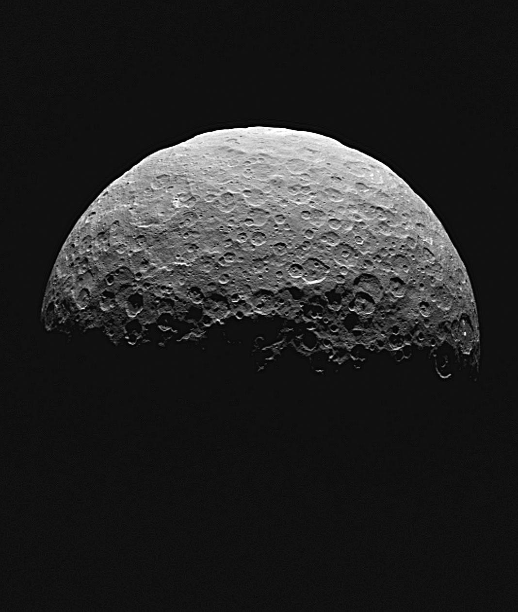
This image of Ceres is part of a sequence taken by NASA's Dawn spacecraft April 24 to 26, 2015, from a distance of 8,500 miles (13,500 kilometers).
An anaglyph of this image can be viewed at PIA19320 - and - File:PIA19320-Ceres-DwarfPlanet-Anaglyph-20150426.jpg
Dawn's mission is managed by JPL for NASA's Science Mission Directorate in Washington. Dawn is a project of the directorate's Discovery Program, managed by NASA's Marshall Space Flight Center in Huntsville, Alabama. UCLA is responsible for overall Dawn mission science. Orbital ATK, Inc., in Dulles, Virginia, designed and built the spacecraft. The German Aerospace Center, the Max Planck Institute for Solar System Research, the Italian Space Agency and the Italian National Astrophysical Institute are international partners on the mission team. For a complete list of acknowledgements, visit http://dawn.jpl.nasa.gov/mission.

Extract from original caption: This image, taken 147,000 miles (237,000 kilometers) from Ceres on January 25, 2015 by NASA's Dawn spacecraft, is part of a series of views representing the best look so far at the dwarf planet. The image is 43 pixels across, representing a higher resolution than images of Ceres taken by the Hubble Space Telescope in 2003 and 2004.

Full-frame image of Vesta. NASA's Dawn spacecraft obtained this image of the giant asteroid Vesta with its framing camera on July 24, 2011. It was taken from a distance of about 3,200 miles (5,200 kilometers).

An image of cratered terrain with hills and ridges on Vesta taken by Dawn on August 6, 2011. It has a resolution of about 260 meters per pixel.