Dasht-e Kavir
| Dasht-e Kavir | |
| persiska:دشت كوير, | |
| Öken | |
.jpg) Miljöbild från Dasht-e Kavir. | |
| Etymologi: Klassisk persiska för Låga slätter khwar = låg, dasht = slätt | |
| Land | |
|---|---|
| Bergskedjor | Elburz[1], Zagros[1] |
| Städer | Semnan, Mehdishahr, Sorkheh, Garmsar, Kashan |
| Landmärke | Kavir nationalpark |
| Sjöar | Haj Ali Gholi Salt Lake, Namak Lake |
| Koordinater | 35°00′00″N 54°00′00″Ö / 35.00000°N 54.00000°Ö |
| Längd | 800 km (väst till öst)[1] |
| Bredd | 320 km (nord till syd)[2] |
| Area | 77 600 km² |
| Wikimedia Commons: Dasht-e Kavir | |

Dasht-e Kavir eller Stora saltöknen (persiska:دشت كوير,) är en saltöken i centrala Iran, och är Irans största öken. Den sträcker sig från Teheran i sydostlig riktning. Ytan är cirka 77 600 km². Öknen är till stor del obebodd men det finns en del stora städer runt omkring ökenområdet, exempelvis huvudstaden Teheran, Isfahan, Yazd och Qom
Dasht-e Kavirs utbredningsområde begränsas i norr av bergskedjan Elburz vid Kaspiska havets sydkust och mot sydväst begränsas öknen av bergskedjan Zagros. I nordlig- sydlig riktning sträcker sig öknen ca 300 km från 33°30' N till 36°30 N och i östlig- västlig riktning ca 800 km från 51°15' Ö till 57°50 Ö.[1]
Mitt i Dasht-e Kavir ligger Kavir Buzurg med en utbredning på 320 gånger 160 km[2] som är en kvicksandsliknande sank och gyttjig bassäng överdragen av en tjock skorpa av salt. Kavar Buzura, som är omgiven av sanddyner, är extremt farlig att passera.[1]
På somrarna kan temperaturen i Dasht-e Kavir uppgå till 50 °C, och medeltemperaturen i januari är 22 °C.
Djurliv
Trots det heta och torra klimatet finns en hel del vilt liv mitt i området. Bland annat gaseller, vilda får, getter och leoparder trivs i bergsområdena runt omkring i öknen. Även andra rovdjur finns i öknen, som exempelvis vargar och rävar. Det finns också en hel del ormar, skorpioner och ödlor.
Galleri

![Foto av Dasht-e Kavir taget från Internationella rymdstationen.[3]](//upload.wikimedia.org/wikipedia/commons/thumb/b/b4/Kavir_Desert%2C_Iran_ISS.jpg/150px-Kavir_Desert%2C_Iran_ISS.jpg) Foto av Dasht-e Kavir taget från Internationella rymdstationen.[3]
Foto av Dasht-e Kavir taget från Internationella rymdstationen.[3]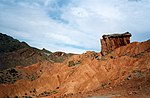 Miljöbild från Dasht-e Kavir.
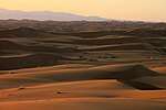 Dasht-e Kavir nära Kashan.
 Satellitbild över Dasht-e Kavir vid position 34°44′15″N 54°49′38″Ö / 34.73750°N 54.82722°Ö.
 Miljöbild från Dasht-e Kavir.
Se även
Referenser
Noter
- ^ [a b c d e] Joyce Quinn / Susan Woodward (2015). ”Dasht-e-Kavir Desert and Dasht-e-Lut Desert” (på engelska). Earth's Landscape: An Encyclopedia of the World's Geographic Features. ASIN: B00SC8OO9U. ABC-CLIO. sid. 196–197. http://www.amazon.co.uk/Earths-Landscape-Encyclopedia-Geographic-Features-ebook/dp/B00SC8OO9U/ref=sr_1_1?s=books&ie=UTF8&qid=1454816002&sr=1-1&keywords=9781610694469
- ^ [a b] ”Dasht-e Kavir” (på engelska). Encyclopedia.com. http://www.encyclopedia.com/doc/1E1-DashteKa.html. Läst 7 februari 2016.
- ^ ”Kavir Desert, Iran” (på engelska). Earth Observatory. http://earthobservatory.nasa.gov/IOTD/view.php?id=83438&src=eoa-iotd. Läst 7 februari 2016.
Tryckta källor
- Joyce Quinn / Susan Woodward (2015) (på engelska). Earth's Landscape: An Encyclopedia of the World's Geographic Features. ASIN: B00SC8OO9U. ABC-CLIO. http://www.amazon.co.uk/Earths-Landscape-Encyclopedia-Geographic-Features-ebook/dp/B00SC8OO9U/ref=sr_1_1?s=books&ie=UTF8&qid=1454816002&sr=1-1&keywords=9781610694469
- Den här artikeln är helt eller delvis baserad på material från engelskspråkiga Wikipedia, Dasht-e Kavir, 17 januari 2016.
Media som används på denna webbplats

Flag of Iran. The tricolor flag was introduced in 1906, but after the Islamic Revolution of 1979 the Arabic words 'Allahu akbar' ('God is great'), written in the Kufic script of the Qur'an and repeated 22 times, were added to the red and green strips where they border the white central strip and in the middle is the emblem of Iran (which is a stylized Persian alphabet of the Arabic word Allah ("God")).
The official ISIRI standard (translation at FotW) gives two slightly different methods of construction for the flag: a compass-and-straightedge construction used for File:Flag of Iran (official).svg, and a "simplified" construction sheet with rational numbers used for this file.
.svg)

As the astronauts on the International Space Station passed over the deserts of central Iran recently, they were greeted by this striking pattern of parallel lines and sweeping curves. The lack of soil and vegetation in the Kavir desert (Dasht-e Kavir) allows the geological structure of the rocks to appear quite clearly. The patterns result from the gentle folding of numerous, thin layers of rock. Later erosion by wind and water cut a flat surface across the dark- and light-colored folds, not only exposing hundreds of layers but also showing the shapes of the folds. The pattern has been likened to the layers of a sliced onion. The dark water of a lake (image center) fills a depression in a more easily eroded, S-shaped layer of rock. The irregular, light-toned patch just left of the lake is a sand sheet thin enough to allow the underlying rock layers to be detected. A small river snakes across the bottom of the image. In this desert landscape, there are no fields or roads to give a sense of scale. In fact, the width of the image is about 105 kilometers (65 miles).
.jpg)
Författare/Upphovsman: Jeanne Menj, Licens: CC BY 2.0
Iran - Dasht-e-Kavir desert Le désert Iranian comprend deux zones distinctes, le Dasht-e-Kavir, ou désert de Kavir, et le Dasht-e-Lut, ou désert de Lut. Le mot perse "dash" signifie “desert”. En gros, sur le trajet qui va de Machad à Ispahan, le Dasht-e-Kavir est côté nord, et le Dasht-e-lut est côté sud.
Le Dasht-e-Lut comprend de riches réserves de pétrole.
Författare/Upphovsman: Jeanne Menj, Licens: CC BY 2.0
Iran - dans le désert Dasht-e-Kevir

A satellite picture of the Dasht-e Kavir desert in Iran.
The patterns you see are formed by different geological layers that have been eroded over thousands of years by wind and sometimes (but not often) rain.
The patterns are formed from either horizontal geological layers cut through by topographic changes, or geological formations (folds, domes, etc) in relatively flat terrain.
Most of the colours are due to chemical differences in the rocks, whilst the intense blue colours could be due to a range of materials, possibly salt deposits, possibly vegetation, depending on which area of the EM spectrum is represented by blue. I suspect (but don't know, the satellite bands to displayed colours are not mentioned) that the blue colours are salt deposits, but they could equally be other materials too. To be certain, knowledge of the bands to display colours is essential.
The black line running horizontally across the image is a sensor drop-out and the data for that line or lines has been irrevocably lost. The linear (but not straight) line running vertically down the middle left is a road.
USGS/NASA description: The Dasht-e Kevir, or Great Salt Desert, is the largest desert in Iran. It is primarily uninhabited wasteland, composed of mud and salt marshes covered with crusts of salt that protect the meager moisture from completely evaporating. This image was acquired by Landsat 7’s Enhanced Thematic Mapper plus (ETM+) sensor on October 24, 2000. This is a false-color composite image made using infrared, green, and red wavelengths. The image has also been sharpened using the sensor’s panchromatic band.Författare/Upphovsman: Fabienkhan, Licens: CC BY-SA 2.5
Simplified/improved version of Image:Iran biotopes.png, in french
.jpg)
Författare/Upphovsman: Jeanne Menj, Licens: CC BY 2.0
Le désert Iranian comprend deux zones distinctes, le Dasht-e-Kavir, ou désert de Kavir, et le Dasht-e-Lut, ou désert de Lut. Le mot perse "dash" signifie “desert”. En gros, sur le trajet qui va de Machad à Ispahan, le Dasht-e-Kavir est côté nord, et le Dasht-e-lut est côté sud.
Le Dasht-e-Lut comprend de riches réserves de pétrole.
Författare/Upphovsman: http://www.maps-for-free.com/, Licens: GFDL
Dasht-e Kavir