Danville, Pennsylvania
| Danville | |
| borough | |
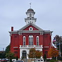
Domstolsbyggnaden | |
| Land | |
|---|---|
| Delstat | Pennsylvania |
| County | Montour County |
| Höjdläge | 200 m ö.h. |
| Koordinater | 40°57′48″N 76°36′46″V / 40.96333°N 76.61278°V |
| Yta | 4,08 km² (2010) |
| - land | 4,03 km² |
| - vatten | 0,05 km² |
| Folkmängd | 4 699 (2010) |
| Befolkningstäthet | 1 166 invånare/km² |
| Tidszon | EST (UTC-5) |
| - sommartid | EDT (UTC-4) |
| ZIP-kod | 17821–17822 |
| Riktnummer | 570 |
| FIPS | 4218136 |
| Geonames | 5186327 |
Ortens läge i Pennsylvania | |
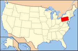
Pennsylvanias läge i USA | |
| Webbplats: danvilleboro.org | |
Danville är administrativ huvudort i Montour County i delstaten Pennsylvania.[1][2][3] Enligt 2010 års folkräkning hade Danville 4 699 invånare.[4]
Källor
- ^ Pennsylvania County Map with County Seat Cities. Geology.com Geoscience News and Information. Läst 2 februari 2018.
- ^ Danville, PA. Map Quest. Läst 2 februari 2018.
- ^ Profile for Danville, Pennsylvania Arkiverad 1 juli 2017 hämtat från the Wayback Machine.. ePodunk. Läst 2 februari 2018.
- ^ 2010 Census Population of Danville, Pennsylvania Arkiverad 2 februari 2018 hämtat från the Wayback Machine.. Census Viewer. Läst 2 februari 2018.
|
Media som används på denna webbplats
Shiny red button/marker widget. Used to mark the location of something such as a tourist attraction.
Författare/Upphovsman: Alexrk2, Licens: CC BY 3.0
Location map of Pennsylvania, USA
Författare/Upphovsman: Smallbones, Licens: CC0
Montour County Courthouse, Danville, Pennsylvania. In the square defined by Market, Mill, and Roonney Streets and Friendship alley. Coords 40.960245,-76.619253
Författare/Upphovsman: Huebi, Licens: CC BY 2.0
Map of USA with Pennsylvania highlighted


