Courtland, Virginia
| Courtland | |
| town | |
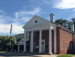
Domstolsbyggnaden | |
| Land | |
|---|---|
| Delstat | Virginia |
| County | Southampton County |
| Höjdläge | 7 m ö.h. |
| Koordinater | 36°42′59″N 77°4′5″V / 36.71639°N 77.06806°V |
| Yta | 2,4 km² (2010) |
| - land | 2,4 km² |
| - vatten | 0,0 km² |
| Folkmängd | 1 284 (2010) |
| Befolkningstäthet | 535 invånare/km² |
| Tidszon | EST (UTC-5) |
| - sommartid | EDT (UTC-4) |
| ZIP-kod | 23837 |
| Riktnummer | 757 |
| FIPS | 5119600 |
| Geonames | 4754296 |
Ortens läge i Virginia | |
Virginias läge i USA | |
Courtland är administrativ huvudort i Southampton County i Virginia.[1][2][3] Vid 2010 års folkräkning hade Courtland 1 284 invånare.[4] Domstolsbyggnaden i byggdes 1834–1835.[5]
Orten kallades först Town at the Courthouse. Namnet ändrades till Jerusalem 1791 och till Courtland 1888 när järnvägen nådde orten.[6]
Källor
- ^ Virginia County Map with County Seat Cities. Geology.com Geoscience News and Information. Läst 30 september 2017.
- ^ Courtland, VA. Map Quest. Läst 30 september 2017.
- ^ Profile for Courtland, Virginia Arkiverad 30 september 2017 hämtat från the Wayback Machine.. ePodunk. Läst 30 september 2017.
- ^ 2010 Census Population of Courtland, Virginia Arkiverad 30 september 2017 hämtat från the Wayback Machine.. Census Viewer. Läst 30 september 2017.
- ^ Southampton County. US Courthouses. Läst 30 september 2017.
- ^ Southampton County. Virginia Places. Läst 22 augusti 2021.
Media som används på denna webbplats
Shiny red button/marker widget. Used to mark the location of something such as a tourist attraction.
Författare/Upphovsman: Mojo Hand, Licens: CC BY-SA 4.0
County courthouse, Southampton Virginia
Författare/Upphovsman: Huebi, Licens: CC BY 2.0
Map of USA with Virginia highlighted
Författare/Upphovsman: Alexrk2, Licens: CC BY 3.0
Location map of Virginia, USA


