County Durham (distrikt)

County Durham
Durham
enhetskommun
Durham
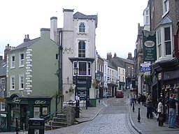
(c) Nicholas Mutton, CC BY-SA 2.0
Flagga
LandStorbritannien Storbritannien
RiksdelEngland
GrevskapDurham
Koordinater54°46′36″N 1°34′33″V / 54.7768°N 1.57575°V / 54.7768; -1.57575
Area2 226 km²
Folkmängd493 470 (2011)[1]
Befolkningstäthet222 invånare/km²
TidszonUTC (UTC+0)
 - sommartidBST (UTC+1)
ISO 3166-2-kodGB-DUR-
Geonames2650629
Contains Ordnance Survey data © Crown copyright and database right, CC BY-SA 3.0

County Durham är en enhetskommun i Durham ceremoniellt grevskap i Storbritannien.[1] Det ligger i riksdelen England, i den centrala delen av landet, 400 km norr om huvudstaden London. Antalet invånare är 493 470.[1] Arean är 2 226 kvadratkilometer.

Terrängen i County Durham är kuperad åt sydväst, men åt nordost är den platt.[a]

County Durham delas in i:

  • Brandon and Byshottles
  • Lartington
  • Mickleton
  • Tow Law
  • Great Lumley
  • Shincliffe
  • Stanhope
  • Thornley
  • Wackerfield
  • Windlestone
  • Wingate
  • Witton Gilbert
  • Wolsingham
  • LCPs of Hamsterley, Lynesack and Softley, and South Bedburn
  • Belmont
  • Bolam
  • Boldron
  • Bowes
  • Cassop-cum-Quarrington
  • Chilton
  • Cleatlam
  • Egglestone Abbey
  • Esh
  • Evenwood and Barony
  • Ferryhill
  • Fishburn
  • Great Aycliffe
  • Haswell
  • Headlam
  • Hutton Magna
  • Langleydale and Shotton
  • Middridge
  • Murton
  • Newbiggin
  • North Lodge
  • Ovington
  • Pelton
  • Rokeby
  • Scargill
  • Sedgefield
  • Shildon
  • South Bedburn
  • Spennymoor
  • Staindrop
  • Startforth
  • West Auckland
  • Westwick
  • Witton-le-Wear
  • Woodland
  • Wycliffe with Thorpe
  • Seaton with Slingley
  • LCPs of Brancepeth and Brandon and Byshottles
  • Barnard Castle
  • Bournmoor
  • Cornforth
  • Cornsay
  • Cotherstone
  • Dalton-le-Dale
  • Dene Valley
  • Edmondsley
  • Eldon
  • Etherley
  • Gainford
  • Greater Willington
  • Greencroft
  • Hamsterley
  • Hilton
  • Hunderthwaite
  • Hutton Henry and Station Town
  • Kelloe
  • Marwood
  • Middleton-in-Teesdale
  • Monk Hesleden
  • Morton Tinmouth
  • Nesbitt
  • Romaldkirk
  • Seaham
  • Sheraton with Hulam
  • Sherburn Village
  • Shotton
  • South Hetton
  • Streatlam and Stainton
  • Winston
  • Barforth
  • Barningham
  • Brignall
  • Burnhope
  • Castle Eden
  • Coxhoe
  • Edmondbyers
  • Gilmonby
  • Hedleyhope
  • Holwick
  • Horden
  • Kimblesworth and Plawsworth
  • Langton
  • Lunedale
  • Ouston
  • Peterlee
  • Raby with Keverstone
  • Sacriston
  • Shadforth
  • Stanley
  • Trimdon
  • Trimdon Foundry
  • Urpeth
  • West Rainton and Leamside
  • Wheatley Hill
  • LCPs of Stanhope, Wolsingham and Tow Law
  • Pittington
  • Waldridge
  • Whorlton
  • Bearpark
  • Little Lumley
  • Bishop Auckland
  • Bishop Middleham
  • Bradbury and the Isle
  • Brancepeth
  • Cockfield
  • Croxdale and Hett
  • Easington Colliery
  • Easington Village
  • Eggleston
  • Forest and Frith
  • Framwellgate Moor
  • Hawthorn
  • Healeyfield
  • Hope
  • Hunstanworth
  • Ingleton
  • Lanchester
  • Lynesack and Softley
  • Mordon
  • Muggleswick
  • Satley

Följande samhällen finns i County Durham:

  • Durham
  • Houghton-Le-Spring
  • Chester-le-Street
  • Peterlee
  • Newton Aycliffe
  • Bishop Auckland
  • Seaham
  • Consett
  • Spennymoor
  • Stanley
  • Hetton-Le-Hole
  • Ferryhill
  • Annfield Plain
  • Shildon
  • Crook
  • Barnard Castle
  • Ushaw Moor
  • Pelton
  • Easington Colliery
  • Esh
  • Wingate
  • Castleside
  • Sedgefield
  • Langley Park
  • Sacriston
  • Burnopfield
  • Lanchester
  • Coxhoe
  • Trimdon
  • Thornley
  • South Hetton
  • Fishburn
  • West Cornforth
  • Witton Gilbert
  • West Rainton
  • High Etherley
  • Wolsingham
  • Tow Law
  • Evenwood
  • Stanhope
  • Ingleton
  • Tanfield
  • Cotherstone
  • Hawthorn
  • Bowes
  • Mickleton
  • Whorlton
  • Binchester
  • Barningham
  • Ovington
  • Hutton Magna
  • Romaldkirk
  • Lartington

I övrigt finns följande i County Durham:

  • Vattendrag:
  • Vattenfall:
  • Insjöar:
    • Grassholme Reservoir (en reservoar)
    • Selset Reservoir (en reservoar)
  • Kullar:
    • Collier Law (en kulle)
  • Berg:
    • Fendrith Hill (ett berg)
    • Mickle Fell (ett berg)
    • Pawlaw Pike (ett berg)

Kustklimat råder i trakten.[3] Årsmedeltemperaturen i trakten är 8 °C. Den varmaste månaden är juli, då medeltemperaturen är 15 °C, och den kallaste är januari, med 0 °C.[4]

Kommentarer

  1. ^ Framräknat ur höjduppgifter (DEM 3") från Viewfinder Panoramas.[2] Mer om algoritmen finns här: Användare:Lsjbot/Algoritmer.

Källor

  1. ^ [a b c] County Durham hos Geonames.org (cc-by); post uppdaterad 2015-06-16; databasdump nerladdad 2016-05-06
  2. ^ ”Viewfinder Panoramas Digital elevation Model”. http://www.viewfinderpanoramas.org/dem3.html. Läst 21 juni 2015. 
  3. ^ Peel, M C; Finlayson, B L; McMahon, T A (2007). ”Updated world map of the Köppen-Geiger climate classification”. Hydrology and Earth System Sciences 11: sid. 1633-1644. doi:10.5194/hess-11-1633-2007. http://www.hydrol-earth-syst-sci.net/11/1633/2007/hess-11-1633-2007.html. Läst 30 januari 2016. 
  4. ^ ”NASA Earth Observations Data Set Index”. NASA. Arkiverad från originalet den 10 maj 2020. https://web.archive.org/web/20200510015442/http://neo.sci.gsfc.nasa.gov/dataset_index.php. Läst 30 januari 2016. 

Externa länkar

Media som används på denna webbplats

Robot icon.svg
Robot icon
County Durham Council UK locator map.svg
Contains Ordnance Survey data © Crown copyright and database right, CC BY-SA 3.0

Map of County Durham, UK with County Durham council highlighted.

Equirectangular map projection on WGS 84 datum, with N/S stretched 170%
Main Street, Durham City Centre - geograph.org.uk - 997591.jpg
(c) Nicholas Mutton, CC BY-SA 2.0
Main Street, Durham City Centre
Flag of Durham County Council.svg
Författare/Upphovsman: Ch1902, Licens: CC BY-SA 3.0
Banner of the arms of Durham County Council