Cotton Plant
| Cotton Plant | |
| city | |
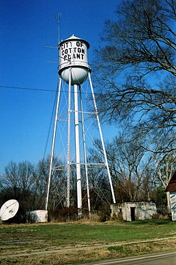
Vattentornet i Cotton Plant. | |
| Land | |
|---|---|
| Delstat | Arkansas |
| County | Woodruff County |
| Höjdläge | 59 m ö.h. |
| Koordinater | 35°0′29″N 91°15′4″V / 35.00806°N 91.25111°V |
| Yta | 2,7 km² (2010) |
| - land | 2,7 km² |
| - vatten | 0,0 km² |
| Folkmängd | 649 (2010) |
| Befolkningstäthet | 240 invånare/km² |
| Tidszon | CST (UTC-6) |
| - sommartid | CDT (UTC-5) |
| ZIP-kod | 72036 |
| Riktnummer | 870 |
| FIPS | 0515550 |
| Geonames | 4106733 |
Ortens läge i Arkansas | |
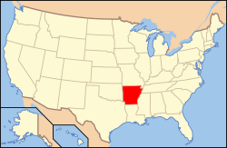
Arkansas läge i USA | |
Cotton Plant är en ort i Woodruff County i Arkansas.[1][2] Vid 2010 års folkräkning hade Cotton Plant 649 invånare.[3]
Kända personer från Cotton Plant
- Pearl Peden Oldfield, politiker
- Sister Rosetta Tharpe, musiker
Källor
- ^ Cotton Plant, AR. Map Quest. Läst 25 oktober 2017.
- ^ Profile for Cotton Plant, Arkansas Arkiverad 25 oktober 2017 hämtat från the Wayback Machine.. ePodunk. Läst 25 oktober 2017.
- ^ 2010 Census Population of Cotton Plant, Arkansas Arkiverad 25 oktober 2017 hämtat från the Wayback Machine.. Census Viewer. Läst 25 oktober 2017.
Media som används på denna webbplats
Shiny red button/marker widget. Used to mark the location of something such as a tourist attraction.
Författare/Upphovsman: Alexrk2, Licens: CC BY 3.0
Den här Det karta skapades med GeoTools.
Författare/Upphovsman: Luke, Licens: CC BY-SA 2.0
Cotton Plant Arkansas. Water tower on a non-overcast winter day. Seems to be leaning a bit from this angle.
The small building at the lower right was, for many years, the city jail. It was a dungeon in the strictest of terms. Most held here, were only held as long as it took to sober up. True "bad guys" occasionally passed threw here on their way to a real "hell on earth", the Arkansas prison system. The parabolic disc on the left is what is left of a "get rich quick" cable system that folded in the late seventies.Författare/Upphovsman: Huebi, Licens: CC BY 2.0
Map of USA with Arkansas highlighted


