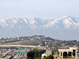
Corona, Kalifornien
| Corona | |
| city | |
| Land | |
|---|---|
| Delstat | Kalifornien |
| County | Riverside County |
| Koordinater | 33°51′44″N 117°33′49″V / 33.86222°N 117.56361°V |
| Yta | 101 km² (2010)[1] |
| - land | 101 km² |
| - vatten | 0,3 km² |
| Folkmängd | 155 896 (2011)[2] |
| Befolkningstäthet | 1 544 invånare/km² |
| Tidszon | PST (UTC-8) |
| - sommartid | PDT (UTC-7) |
| ZIP-kod | 92503, 92860, 92879–92883[3] |
| FIPS | 0616350 |
| Geonames | 5339631 |
Ortens läge i Kalifornien | |
Kaliforniens läge i USA | |
| Webbplats: http://www.ci.corona.ca.us/ | |
Corona är en stad i Riverside County i den amerikanska delstaten Kalifornien med en yta av 91,1 km² och en folkmängd som uppgår till 124 966 invånare (2000).
Kända personer från Corona
- Ken Calvert, politiker
- Michael Parks, skådespelare
- Tyler Hoechlin, skådespelare
Källor
- ^ ”2010 Census Gazetteer Files”. US Census Bureau. Arkiverad från originalet den 14 juli 2012. https://www.webcitation.org/699nOulzi?url=http://www.census.gov/geo/www/gazetteer/files/Gaz_places_national.txt. Läst 14 juli 2012.
- ^ ”Corona (city), California” (på engelska). State & County Quickfacts. U.S. Census Bureau,. Arkiverad från originalet den 17 augusti 2012. https://www.webcitation.org/69ytRFvjZ?url=http://quickfacts.census.gov/qfd/states/06/0616350.html. Läst 17 augusti 2012.
- ^ ”2010 ZIP Code Tabulation Area (ZCTA) Relationship Files”. U.S. Census Bureau. 2 augusti 2010. Arkiverad från originalet den 25 augusti 2012. https://www.webcitation.org/6ABdwXxbq?url=http://www.census.gov/geo/www/2010census/zcta_rel/zcta_place_rel_10.txt. Läst 25 augusti 2012.
Externa länkar
 Wikimedia Commons har media som rör Corona, Kalifornien.
Media som används på denna webbplats
Shiny red button/marker widget. Used to mark the location of something such as a tourist attraction.
Författare/Upphovsman: Huebi, Licens: CC BY 2.0
Map of USA with California highlighted
Författare/Upphovsman: NordNordWest, Licens: CC BY 3.0
Location map of California, USA
A View of Corona, California, view looking north-northwest. The Interstate 15 and California State Route 91 interchange is picture in the foreground (bottom left corner) while the San Gabriel Mountains loom in the background.


