Converse County
| Converse County | |
| County | |
Landskapsvy nära Douglas | |
| Land | |
|---|---|
| Delstat | |
| Huvudort | Douglas |
| Största stad | Douglas |
| Area | 11 046 km² (2010)[1] |
| - land | 11 020 km² (100%) |
| - vatten | 26,4 km² (0%) |
| Folkmängd | 13 833 (2010)[2] |
| Befolkningstäthet | 1,3 invånare/km² |
| Grundat | 1888 |
| - uppkallat efter | A. R. Converse |
| Tidszon | MST (UTC-7) |
| - sommartid | MDT (UTC-6) |
| FIPS-kod | 56009 |
| Geonames | 5821791 |
 Läge i delstaten Wyoming. | |
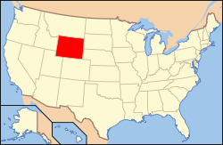
Delstatens läge i USA. | |

Converse County är ett county i delstaten Wyoming, USA, med 13 833 invånare. Den administrativa huvudorten (county seat) är Douglas.
Historia
Countyt skapades 1888 genom avstyckning av mark som tidigare tillhörde Albany County och Laramie County, och döptes efter A.R. Converse, en bankir och ranchägare från Cheyenne. Converse ägde tillsammans med Francis E. Warren en större ranch i östra delen av Converse County.
Countyts gränser har sedan tillkomsten förändrats två gånger, 1911, då Niobrara County avstyckades från Converse County, och 1955, då gränsen mot Albany County flyttades så att mindre delar av Albany County tillföll Converse County.
Geografi
Enligt United States Census Bureau har countyt en total area på 11 046 km². 11 020 km² av den arean är land och 26 km² är vatten.
Angränsande countyn
- Campbell County, Wyoming - nord
- Weston County, Wyoming - nordöst
- Niobrara County, Wyoming - öst
- Platte County, Wyoming - sydöst
- Albany County, Wyoming - syd
- Carbon County, Wyoming - sydväst
- Natrona County, Wyoming - väst
- Johnson County, Wyoming - nordväst
Federala naturskyddsområden
- Medicine Bow – Routt National Forest (delvis)
- Thunder Basin National Grassland (delvis)
Orter
Invånarantal i parentes anges för 2010 års folkräkning.
Städer (Cities)
I Wyoming definieras cities normalt som städer med kommunalt självstyre och över 4 000 invånare.
- Douglas (huvudort, 6 120 invånare)
Småstäder (Towns)
I Wyoming definieras towns som städer med kommunalt självstyre men under 4 000 invånare.
- Glenrock (2 576)
- Lost Springs (4)
- Rolling Hills (440)
Följande orter har inte kommunalt självstyre och administreras direkt av Converse County.
- Esterbrook (52)
- Orin (46)
Andra platser
Större vägar
 Interstate 25
 U.S. Route 18
 U.S. Route 20
 U.S. Route 26
 U.S. Route 287
 Wyoming Highway 59
Sevärdheter
- Ayres Natural Bridge, naturlig klippbåge.
- Douglas Railroad Interpretive Center, järnvägsmuseum.
- Fort Fetterman, delvis rekonstruerat historiskt fort från indiankrigen.
- Wyoming State Fair hålls i Douglas årligen i augusti.
Källor
Noter
- ^ ”2010 Census U.S. Gazetteer Files for Counties”. U.S. Census Bureau. Arkiverad från originalet den 5 juli 2012. https://www.webcitation.org/68vYLbou5?url=http://www.census.gov/geo/www/gazetteer/files/Gaz_counties_national.txt. Läst 5 juli 2012.
- ^ ”State & County QuickFacts, Converse County, Wyoming” (på engelska). U.S. Census Bureau. Arkiverad från originalet den 9 juli 2011. https://www.webcitation.org/602dJqJEp?url=http://quickfacts.census.gov/qfd/states/56/56009.html. Läst 6 juli 2011.
Externa länkar
 Wikimedia Commons har media som rör Converse County.
| ||||||||||
Media som används på denna webbplats
600 mm × 600 mm (24 in × 24 in) U.S. Highway shield, made to the specifications of the 2004 edition of Standard Highway Signs. (Note that there is a missing "J" label on the left side of the diagram.) Uses the Roadgeek 2005 fonts. (United States law does not permit the copyrighting of typeface designs, and the fonts are meant to be copies of a U.S. Government-produced work anyway.)
750 mm × 600 mm (30 in × 24 in) U.S. Highway shield, made to the specifications of the 2004 edition of Standard Highway Signs. (Note that there is a missing "J" label on the left side of the diagram.) Uses the Roadgeek 2005 fonts. (United States law does not permit the copyrighting of typeface designs, and the fonts are meant to be copies of a U.S. Government-produced work anyway.)
Författare/Upphovsman: Wusel007, Licens: CC BY-SA 3.0
Typical example for the landscape in Converse County at Wagonhound Rd, close to Douglas, WY
This is a locator map showing Converse County in Wyoming. For more information, see Commons:United States county locator maps.
Författare/Upphovsman: This version: uploader
Base versions this one is derived from: originally created by en:User:Wapcaplet, Licens: CC BY 2.0
Map of USA with Wyoming highlighted
600 mm × 600 mm (24 in × 24 in) U.S. Highway shield, made to the specifications of the 2004 edition of Standard Highway Signs. (Note that there is a missing "J" label on the left side of the diagram.) Uses the Roadgeek 2005 fonts. (United States law does not permit the copyrighting of typeface designs, and the fonts are meant to be copies of a U.S. Government-produced work anyway.)
600 mm × 600 mm (24 in × 24 in) U.S. Highway shield, made to the specifications of the 2004 edition of Standard Highway Signs. (Note that there is a missing "J" label on the left side of the diagram.) Uses the Roadgeek 2005 fonts. (United States law does not permit the copyrighting of typeface designs, and the fonts are meant to be copies of a U.S. Government-produced work anyway.)


