Contra Costa County
| Contra Costa County | |
| County | |
| Land | |
|---|---|
| Delstat | |
| Huvudort | Martinez |
| Area | 2 082 km² (2010)[1] |
| - land | 1 854 km² (89%) |
| - vatten | 227 km² (11%) |
| Folkmängd | 1 049 025 (2010)[2] |
| Befolkningstäthet | 566 invånare/km² |
| Grundat | 18 februari 1850 |
| Tidszon | PST (UTC-8) |
| - sommartid | PDT (UTC-7) |
| FIPS-kod | 06013 |
| Geonames | 5339268 |
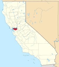
Läge i delstaten Kalifornien. | |
Delstatens läge i USA. | |
Contra Costa County är ett county i delstaten Kalifornien, USA. År 2010 hade Contra Costa County 1 049 025 invånare. Den administrativa huvudorten (county seat) är Martinez.
Geografi
Enligt United States Census Bureau så har countyt en total area på 2 078 km². 1 865 km² av den arean är land och 190 km² är vatten.
Angränsande countyn
- Alameda County - syd
- Marin County - väst
- Solano County - nord
- Sacramento County - nordost
- San Joaquin County - öst
- San Francisco County - sydväst
Städer och samhällen
Östra delarna: Bayview-Montalvin, Crockett, East Richmond Heights, El Cerrito, El Sobrante, Hercules, Kensington, North Richmond, Pinole, Port Costa, Richmond, Rodeo, Rollingwood, San Pablo, Tara Hills, Central County
Centrala delarna: Alamo, Blackhawk-Camino Tassajara, Canyon, Clayton, Clyde, Concord, Danville, Diablo, Lafayette, Martinez, Moraga, Mountain View, Orinda, Pacheco, Pleasant Hill, San Ramon, Vine Hill, Waldon, Walnut Creek
Östra delarna: Antioch, Bay Point, Bethel Island, Brentwood, Byron, Discovery Bay, Knightsen, Oakley, Pittsburg
Källor
- ^ ”2010 Census U.S. Gazetteer Files for Counties”. U.S. Census Bureau. Arkiverad från originalet den 5 juli 2012. https://www.webcitation.org/68vYLbou5?url=http://www.census.gov/geo/www/gazetteer/files/Gaz_counties_national.txt. Läst 5 juli 2012.
- ^ ”State & County QuickFacts, Contra Costa County, Kalifornien” (på engelska). U.S. Census Bureau. Arkiverad från originalet den 9 juli 2011. https://www.webcitation.org/602dEHCkC?url=http://quickfacts.census.gov/qfd/states/06/06013.html. Läst 6 juli 2011.
| ||||||||||
|
Media som används på denna webbplats
Flag of California. This version is designed to accurately depict the standard print of the bear as well as adhere to the official flag code regarding the size, position and proportion of the bear, the colors of the flag, and the position and size of the star.
Författare/Upphovsman: Huebi, Licens: CC BY 2.0
Map of USA with California highlighted
This is a locator map showing Contra Costa County in California. For more information, see Commons:United States county locator maps.


