Concarneau
| Concarneau | ||
| Kommun | ||
 | ||
| ||
| Land | ||
|---|---|---|
| Region | ||
| Departement | ||
| Arrondissement | Quimper | |
| Kanton | Concarneau | |
| Koordinater | 47°52′N 3°55′V / 47.867°N 3.917°V | |
| Yta | 41,08 km²[1] | |
| Folkmängd | 20 607 ()[2] | |
| Befolkningstäthet | 502 invånare/km² | |
| Borgmästare | André Fidelin (2014–)[3] | |
| Tidszon | CET (UTC+1) | |
| - sommartid | CEST (UTC+2) | |
| Postnummer | 29900 | |
| INSEE | 29039 | |
| Geonames | 3024035 | |
| OSM-karta | 166492 | |
 Kommunens läge i regionen Bretagne i Frankrike | ||
| Webbplats: https://www.concarneau.fr/ville/ | ||

Concarneau är en kommun i departementet Finistère i regionen Bretagne i västra Frankrike. Kommunen ligger i kantonen Concarneau som tillhör arrondissementet Quimper. År 2021 hade Concarneau 20 607 invånare.
Befolkningsutveckling
Antalet invånare i kommunen Concarneau
Referens:INSEE[4]
Galleri


 Concarneau från SPOT
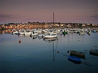
Se även
Källor
- ^ Répertoire géographique des communes, Institut national de l'information géographique et forestière, läst: 26 oktober 2015.[källa från Wikidata]
- ^ Populations légales 2021, Institut National de la Statistique et des Études Économiques, 28 december 2023.[källa från Wikidata]
- ^ Inrikesministeriet, Franska nationella registret över valda tjänstemän, läst: 15 mars 2019.[källa från Wikidata]
- ^ Chiffres clés - Évolution et structure de la population Arkiverad 5 juli 2012 hämtat från the Wayback Machine.
Externa länkar
 Wikimedia Commons har media som rör Concarneau.
Media som används på denna webbplats

Författare/Upphovsman: Eric Gaba (Sting - fr:Sting), Licens: CC BY-SA 4.0
Blank physical map of metropolitan France for geo-location purpose.
Scale : 1:14 816 000 (accuracy : about 3,7 km) for the bathymetry. More maps of France, view → Commons Atlas of France.

Shiny red button/marker widget. Used to mark the location of something such as a tourist attraction.

Författare/Upphovsman: Tango7174, Licens: CC BY-SA 4.0
Concarneau, Finistère, Bretagne, France. The yachting harbour.

Författare/Upphovsman: Tango7174, Licens: CC BY-SA 4.0
Concarneau, Finistère, Bretagne, France. The harbour at dusk.

Författare/Upphovsman: Julien1978, Licens: CC BY-SA 3.0
Vidéo de la baie de Concarneau

Författare/Upphovsman: Tango7174, Licens: CC BY-SA 4.0
Concarneau, Finistère, Bretagne, France. The commercial harbour.

Författare/Upphovsman: Cnes - Spot Image, Licens: CC BY-SA 3.0
Concarneau by SPOT Satellite (de gauche à droite : la Pointe de Mousterlin, Beg Meil, la Baie de la Forêt (Cap Coz, La Forêt-Fouesnant, Port-la-Forêt), Concarneau)


Författare/Upphovsman: Pierre Audité, Licens: CC BY-SA 3.0
Coat of Arms of Finistère, France
.svg)
Författare/Upphovsman: Jack Mamelet, Licens: CC BY-SA 3.0
Airial photo of the Ville Close, Concarneau, Finistère, Brittany, France

Författare/Upphovsman: LudovicRivallain, Licens: CC BY-SA 3.0
Ferryboat at the city of Concarneau "le Gouverneur" Brittany, France.
Författare/Upphovsman:
|
Map data (c) OpenStreetMap contributors, CC-BY-SA _French_municipality_map.svg) • Shape files infrastructure: railway, highways, water: all originally by OpenStreetMap contributors. Status december 2011 *note: shown commune boundaries are from OSM dump May 2012; at that time about 90% complete |
Map commune FR insee code 29039.png