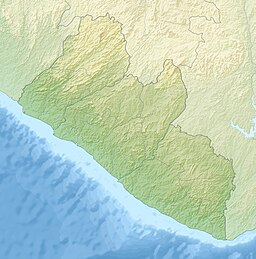
Commonwealth Robertsport District
| Commonwealth Robertsport | |
| Commonwealth | |
| Distrikt | |
| Land | |
|---|---|
| Region | Grand Cape Mount County |
| Koordinater | 6°42′09″N 11°19′13″V / 6.70237°N 11.32017°V |
| Tidszon | UTC (UTC+0) |
| Geonames | 9645004 |
Läge i Liberia | |
Commonwealth Robertsport eller the Commonwealth är ett distrikt i Liberia.[1][2] Det ligger i Grand Cape Mount County, i den västra delen av landet, 70 km nordväst om huvudstaden Monrovia.
Källor
- ^ ”2022 Liberia Population and Housing Census: Final Results” (på engelska) (PDF). Liberia Institute of Statistics and Geo-Information Services. Juni 2023. sid. 84. Arkiverad från originalet den 12 augusti 2024. https://web.archive.org/web/20240812104604/https://www.lisgis.gov.lr/document/LiberiaCensus2022Report.pdf. Läst 16 september 2024.
- ^ County Development Committee, in collaboration with the Ministries of Planning and Economic Affairs and Internal Affairs. Grand Cape Mount County Development Agenda. Ministry of Internal Affairs, Liberia. http://www.mia.gov.lr/doc/Grand%20Cape%20Mount%20CDA_web.pdf.
Media som används på denna webbplats
Shiny red button/marker widget. Used to mark the location of something such as a tourist attraction.
Författare/Upphovsman: Uwe Dedering, Licens: CC BY-SA 3.0
Relief location map of Liberia.
- Projection: Equirectangular projection, strechted by 101.0%.
- Geographic limits of the map:
- N: 8.8° N
- S: 4.0° N
- W: -11.8° E
- E: -7.0° E
- GMT projection: -JX16.933333333333334cd/17.102666666666668cd
- GMT region: -R-11.8/4.0/-7.0/8.8r
- GMT region for grdcut: -R-11.8/4.0/-7.0/8.8r
- Relief: SRTM30plus.
- Made with Natural Earth. Free vector and raster map data @ naturalearthdata.com.


