Columbus, Nebraska
| Columbus | |
| Stad (city) | |
| Uppkallad efter: Columbus | |
| Land | |
|---|---|
| Delstat | |
| County | Platte County |
| Höjdläge | 441 m ö.h. |
| Koordinater | 41°25′46″N 97°21′29″V / 41.42944°N 97.35806°V |
| Area | 27,43 km² (2020)[1] |
| - land | 26,75 km² (2020) |
| - vatten | 0,68 km² (2020) |
| Folkmängd | 24 028 (2020)[2][3] |
| Befolkningstäthet | 898 invånare/km² |
| Grundad | 1856 |
| Tidszon | CST (UTC-6) |
| - sommartid | CDT (UTC-5) |
| ZIP-kod | 68601 |
| Riktnummer | 402 |
| GNIS-kod | 828280 |
| Geonames | 5066001 |
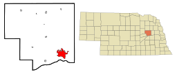
Columbus i Platte County och Nebraska | |
Nebraskas läge i USA | |
| Wikimedia Commons: Columbus, Nebraska | |
| Webbplats: http://www.columbusne.us/ | |
| Redigera Wikidata | |
Columbus är en stad (city) i Platte County i delstaten Nebraska i USA. Staden hade 24 028 invånare, på en yta av 27,43 km² (2020).[4][5] Columbus är administrativ huvudort (county seat) i Platte County.
Staden ligger i delstatens östra del, cirka 88 kilometer nordväst om huvudstaden Lincoln.
Referenser
- ^ Gazetteer Files – 2020 (på engelska), United States Census Bureau, läs online, läst: 20 december 2021.[källa från Wikidata]
- ^ Explore Census Data – Columbus city, Nebraska (på engelska), United States Census Bureau, läs online, läst: 20 december 2021.[källa från Wikidata]
- ^ United States Census Bureau (red.), USA:s folkräkning 2020, läs online, läst: 1 januari 2022.[källa från Wikidata]
- ^ ”Explore Census Data – Columbus city, Nebraska” (på engelska). United States Census Bureau. https://data.census.gov/cedsci/profile?g=1600000US3110110. Läst 20 december 2021.
- ^ ”Gazetteer Files – 2020” (på engelska). United States Census Bureau. https://www.census.gov/geographies/reference-files/time-series/geo/gazetteer-files.2020.html. Läst 20 december 2021.
Externa länkar
 Wikimedia Commons har media som rör Columbus.
- Officiell webbplats
Media som används på denna webbplats
Författare/Upphovsman: This version: uploader
Base versions this one is derived from: originally created by en:User:Wapcaplet, Licens: CC BY 2.0
Map of USA with Nebraska highlighted
Författare/Upphovsman: Arkyan, Licens: CC BY-SA 3.0
This map shows the incorporated and unincorporated areas in Platte County, Nebraska, highlighting Columbus in red. It was created with a custom script with US Census Bureau data and modified with Inkscape.
2500 block of 13th Street in Columbus, Nebraska; seen from the southwest. The block is part of the Columbus Commercial Historic District, which is listed in the National Register of Historic Places. The corner building with the mural is the Poesch Building at 2524 13th St.; it was built in 1911 in the twentieth-century commercial vernacular style. The building is a contributing property to the Historic District. The building to its right with the "Kids 'n Treasures" sign, at 2522 13th St, is a non-contributing property in the district.


