Coahuila y Texas
| Coahuila y Tejas | ||||
| Estado Libre y Soberano de Coahuila y Texas (Spanska) | ||||
| ||||
| ||||
.svg) | ||||
| Huvudstad | Saltillo (1824-1833) Monclova (1833-1835) | |||
| Språk | Spanska | |||
| Religion | Katolicism | |||
| Statsskick | Delstat i Mexikos förenta stater | |||
| Bildades | 1824 | |||
| – bildades ur | Coahuila och Provinsen Texas | |||
| Upphörde | 1821 | |||
| – upphörde genom | Republiken Texas frihetskrig | |||
| – uppgick i | Republiken Texas Republiken Mexiko | |||
| Folkmängd – befolkningstäthet | 71 000 (1828) 0,09 inv/km² | |||
| Valuta | Real mexicano | |||
| Idag del av | Texas Coahuila | |||
Coahuila y Tejas var en delstat som bildades 1824 när det första mexikanska kejsardömet efterträddes av förbundsrepubliken Mexikos förenta stater. När Santa Anna 1835 avskaffade förbundsrepubliken och införde en centralstyrd stat gjorde delstaten uppror. Den angloamerikanska befolkningen i Texas utropade 1835 republiken Texas vilken blev de facto en självständig stat. Coahuila ingick 1840 i Republiken Rio Grande, ett kortlivat försök att bryta sig fri från Mexiko.
Gränser
Delstaten bestod av de tidigare spanska provinserna Coahuila och Texas. Det betydde att området kring El Paso i nuvarande Texas tillhörde delstaten Chihuahua och området kring Laredo i nuvarande Texas tillhörde delstaten Tamaulipas.
Statsskick och administration
Delstaten styrdes av en guvernör och en lagstiftande församling om 12 ledamöter, av dessa kom tio från Coahuila och två från Texas. Huvudstad var Saltillo vilken låg i de södra delarna av Coahuila, mer än 1200 km från dess nordligaste gräns. Monclova blev 1833 huvudstad. Delstaten var indelad i flera departementos under en jefe político. Dessa var i sin tur indelade i municipios styrda av en alcalde och en ayuntamiento.
Bilder
 1833
1833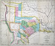 1834
1834 1836
1836
Referenser
- Den här artikeln är helt eller delvis baserad på material från spanskspråkiga Wikipedia, Coahuila y Texas, 28 mars 2016.
Media som används på denna webbplats
.svg)
The Burnet Flag, used from December 10, 1836 to January 25, 1839 as the national flag of the Republic of Texas. It was replaced by the currently used "Lone Star Flag".
The Burnet Flag, used from December 10, 1836 to January 25, 1839 as the national flag of the Republic of Texas. It was replaced by the currently used "Lone Star Flag".

Philadelphia engraver, printer, map publisher, and instrument maker William Hooker's Map of Coahuila and Texas first appeared in an 1833 promotional book on Texas by Mary Austin Holley (1784-1846), a first cousin of the famous Texas colonizer Stephen F. Austin. Holley and her first publisher, Armstrong & Plaskitt of Baltimore substituted Hooker's map when Henry S. Tanner, the publisher of Stephen F. Austin's large map of Texas, refused to allow the latter to be used in the book. Both the 1836 map and book have some significant updates from the earlier map and book. Like the map by Hooker that appeared in A Visit to Texas, published by Goodrich & Wiley in New York in 1834, the 1836 map contains all the details of the earlier 1833 version but indirectly also refers to empresarios John McMullen and James McGloin, James Power, John Cameron, other new details such as "Herds of Buffalo" and "Droves of Wild Cattle & Horses" (phrases copied directly from the Austin-Tanner map) and peaks in the west, "Presidio de Rio Grand" [sic], additional towns across the Rio Grande in Chihuahua and Coahuila, the Cross Timbers, Fort Tenoxtitlan, Comanche Indian lands in the west, Cherokee, Creek, and Choctaw Indian lands north of the Red River. In addition, this 1836 map adds other details, such as references to the grants of Juan Antonio Padilla and Thomas Jefferson Chambers in the panhandle (awarded in 1830), and those of John Charles Beale and Dr. James Grant in the west. Further, the map includes the towns of Bastrop, Gonzales, Cole's Settlement (Independence), Montezuma, Orizumba, Columbia, Bell's Landing, and De Leon's colony. The words "now Filisola" are stamped in northeast Texas next to Thorn's Grant – referring to an empresario land grant awarded in 1831 to Italian-born Mexican Army General Vicente Filisola (1789-1850). Handwritten additions in ink on the map are references to Benjamin Milam's grant in the far northeast and the towns of Washington (on the Brazos), Corpus Christi, and [San] Augustine.

Possible flag for the Mexican state of en:Coahuila y Tejas (1821 - 1836) - colours and dimensions based on Image:Flag of Mexico.svg and Supposed 1821-1836 Coahuila and Texas State flag
.svg)
Flag of Mexico (1821-1823)

Philadelphia engraver, printer, map publisher, and instrument maker William Hooker's Map of Coahuila and Texas first appeared in an 1833 promotional book on Texas by Mary Austin Holley (1784-1846), a first cousin of the famous Texas colonizer Stephen F. Austin. Holley and her publisher, Armstrong & Plaskitt of Baltimore substituted Hooker's map when Henry S. Tanner, the publisher of Stephen F. Austin's large map of Texas, refused to allow the latter to be used in the book. Hooker's map shows the Austin Colony capital town of San Felipe de Austin at the center of roads leading to a number of settlements including Bexar (San Antonio de Bexar), Victoria and Goliad or Bahia, Matagorda, Brazaria (sic, Brazoria), Harrisburg and Buffalo Bayou as well as a road connecting to the older Camino Real or old Spanish road between Bexar and Nacogdoches. Lands granted to individuals under the Mexican empresario system are shown. In addition to Stephen F. Austin's grants awarded in 1821 (confirmed in 1823 and extended by further contracts in 1825, 1827, and 1828), these include the grants of Green DeWitt (contract awarded in 1825), Frost Thorn (1825), Benjamin R. Milam (1826), David G. Burnet (1826), Arthur G. Wavell (1826), Joseph Vehlein (1826 and 1828), Lorenzo de Zavala (1829), Juan Dominguez y Valdez (1829), Richard Exter (1826, 1828), John Charles Beale (1830). The lands in west Texas granted to Beale and José Manuel Royuela and to Austin and his partner Samuel May Williams in 1832 are the latest to appear on the map. References to other land grants are missing but some would appear on later editions in 1834 and 1836.
Författare/Upphovsman: Milenioscuro, Licens: CC BY-SA 4.0
Locator map of Coahuila y Texas state in Mexico (1824)
.svg)
Flag of Mexico (1823-1864, 1867-1893)

Philadelphia engraver, printer, map publisher, and instrument maker William Hooker's Map of Coahuila and Texas first appeared in an 1833 promotional book on Texas by Mary Austin Holley (1784-1846), a first cousin of the famous Texas colonizer Stephen F. Austin. Holley and her publisher, Armstrong & Plaskitt of Baltimore substituted Hooker's map when Henry S. Tanner, the publisher of Stephen F. Austin's large map of Texas, refused to allow the latter to be used in the book. This later colored version Hooker's map appeared in an anonymous travel book on Texas sometime attributed to a certain "M. Fiske" of Mobile, Alabama. The author had sailed from New Orleans in March 1831 and had arrived in Brazoria (incorrectly spelled "Brazaria" on the map) to examine a large tract of land he had purchased from the Galveston Bay and Texas Land Company.
This 1834 map contains all the details of the earlier 1833 version but also refers to John McMullen and James McGloin's grant (contract awarded in 1828), James Power's grant (also awarded in 1828) — both in south Texas — as well as cryptic references to "J. Camerou" in North Texas (John Cameron, who was awarded a contract in 1827) and "De Leon" (Martin De Leon, awarded a contract in 1824). Other new details include "peaks in the west", "Presidio de Rio Grand" [sic], additional towns across the Rio Grande in Chihuahua and Coahuila, the Cross Timbers, "Tenoxticlan" (Fort Tenoxtitlan, constructed for the Mexican army in 1830), "Herds of Buffalo" and "Droves of Wild Cattle & Horses" (phrases copied directly from the Austin-Tanner map), Comanche Indian lands in the west, and Cherokee, Creek, and Choctaw Indian lands north of the Red River.