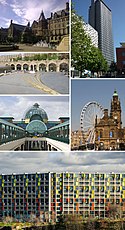
City of Sheffield
| City of Sheffield | |
| Storstadsdistrikt | |
| Land | |
|---|---|
| Riksdel | England |
| Region | Yorkshire och Humber |
| Ceremoniellt grevskap | South Yorkshire |
| Huvudort | Sheffield |
| Area | 368 km²[1] |
| Folkmängd | 566 242 (2022)[2] |
| Befolkningstäthet | 1 539 invånare/km² |
| Tidszon | UTC (UTC+0) |
| - sommartid | BST (UTC+1) |
| ISO 3166-2-kod | GB-SHF- |
| GSS-kod | E08000019 |
| NUTS 3 | UKE32 |
Contains Ordnance Survey data © Crown copyright and database right, CC BY-SA 3.0 Läge i grevskapet South Yorkshire | |
| Webbplats: https://www.sheffield.gov.uk/ | |
City of Sheffield är ett storstadsdistrikt (kommun) i South Yorkshire i England, Storbritannien. Distriktet har 566 242 invånare (2022)[2]. Det är en del av det historiska grevskapet Yorkshire (West Riding). Det fick status som city år 1893.
Förutom storstaden Sheffield så ingår orterna Chapeltown och Stocksbridge i distriktet.
Civil parishes
Större delen av distriktet är inte indelat i civil parishes. Det finns dock tre civil parishes: Bradfield, Ecclesfield och Stocksbridge.[3]
Demografi
Vid folkräkningen 2001 i Storbritannien, utgjordes befolkningen av 91,2 % vita, 4,6 % asiater, 1,8 % svarta och 1,6 % övriga etniciteter. Sheffield har en hög andel invånare från Polen, Somalia, Slovakien, Jemen och Albanien. 68,6 % av befolkningen är kristna och 4,6 % är muslimer. Andra religioner representerade mindre än 1 % var. Antalet personer utan någon religiös tillhörighet är över det nationella snittet på 17,9 %, där 7,8 % inte berättade sin religion.[4] Den största gruppen invånare är mellan 20 och 24 år (9,4 %), främst på grund av den stora universitetsbefolkningen (över 45 000).[5]
| Sheffield jämfört[6][7] | |||
|---|---|---|---|
| Folkräkning 2001 | Sheffield | South Yorkshire | England |
| Totalt antal invånare | 513 234 | 1 266 338 | 49 138 831 |
| Utlandsfödda | 6,4 % | 8,9 % | 9,2 % |
| Vita | 91 % | 95 % | 91 % |
| Asiater | 4,6 % | 2,6 % | 4,6 % |
| Svarta | 1,8 % | 0,9 % | 2,3 % |
| Kristna | 69 % | 75 % | 72 % |
| Muslimer | 4,6 % | 2,5 % | 3,1 % |
| Hinduister | 0,3 % | 0,2 % | 1,1 % |
| Ingen religion | 18 % | 14 % | 15 % |
| Över 75 år | 8,0 % | 7,6 % | 7,5 % |
| Arbetslösa | 4,2 % | 4,1 % | 3,3 % |
Referenser
- ^ ”Estimates of the population for the UK, England, Wales, Scotland, and Northern Ireland (Mid-2022)” (på engelska) (xls). Landyta, avrundad till hela km². Office for National Statistics. 26 mars 2024. https://www.ons.gov.uk/peoplepopulationandcommunity/populationandmigration/populationestimates/datasets/populationestimatesforukenglandandwalesscotlandandnorthernireland. Läst 25 juni 2024.
- ^ [a b] ”Estimates of the population for the UK, England, Wales, Scotland, and Northern Ireland (Mid-2022)” (på engelska) (xls). Office for National Statistics. 26 mars 2024. https://www.ons.gov.uk/peoplepopulationandcommunity/populationandmigration/populationestimates/datasets/populationestimatesforukenglandandwalesscotlandandnorthernireland. Läst 25 juni 2024.
- ^ ”Ordnance Survey linked data”. Ordnance Survey. http://data.ordnancesurvey.co.uk/doc/7000000000009113. Läst 27 juni 2016.
- ^ ”Sheffield. Census 2001”. http://www.statistics.gov.uk/census2001/profiles/00cg.asp.. Office for National Statistics. Hämtat 2005-12-21.
- ^ ”Mid-2005 Population Estimates; Quinary age groups and sex for Primary Care Organisations (PCOs) for England; estimated resident population (experimental). On boundaries as at 1 October 2006”. Arkiverad från originalet den 30 oktober 2007. https://web.archive.org/web/20071030212733/http://www.statistics.gov.uk/StatBase/ssdataset.asp?vlnk=9585&Pos=&ColRank=1&Rank=128.. National Statistics. Office for National Statistics. Hämtat 2007-04-02.
- ^ United Kingdom Census 2001 (2001). South Yorkshire (Met County). statistics.gov.uk. Hämtat 2007-07-11.
- ^ United Kingdom Census 2001 (2001). Sheffield (Local Authority) Arkiverad 18 september 2015 hämtat från the Wayback Machine.. neighbourhood.statistics.gov.uk. Hämtat 2007-07-11.
| ||||||||||||||
| |||||
Media som används på denna webbplats
Contains Ordnance Survey data © Crown copyright and database right, CC BY-SA 3.0
Map of South Yorkshire, UK with Sheffield highlighted.
Equirectangular map projection on WGS 84 datum, with N/S stretched 165%


