City of Bradford
| City of Bradford | ||
| Storstadsdistrikt | ||
| ||
| Land | ||
|---|---|---|
| Riksdel | England | |
| Region | Yorkshire och Humber | |
| Ceremoniellt grevskap | West Yorkshire | |
| Huvudort | Bradford | |
| Area | 366 km²[1] | |
| Folkmängd | 552 644 (2022)[2] | |
| Befolkningstäthet | 1 510 invånare/km² | |
| Tidszon | UTC (UTC+0) | |
| - sommartid | BST (UTC+1) | |
| GSS-kod | E08000032 | |
Contains Ordnance Survey data © Crown copyright and database right, CC BY-SA 3.0 Läge i grevskapet West Yorkshire | ||
| Webbplats: https://www.bradford.gov.uk/ | ||
City of Bradford är ett storstadsdistrikt (kommun) i grevskapet West Yorkshire i England, Storbritannien. Distriktet har 552 644 invånare (2022).[2]
Större orter är huvudorten Bradford samt Baildon, Bingley, Ilkley, Keighley och Shipley.
Civil parishes
Staden Bradford och orten Queensbury är inte indelade i civil parishes. Resten av distriktet består av 21 civil parishes:
- Addingham, Baildon, Bingley, Burley, Clayton, Cullingworth, Denholme, Harden, Haworth, Cross Roads and Stanbury, Ilkley, Keighley, Menston, Oxenhope, Sandy Lane, Silsden, Steeton with Eastburn, Trident, Wilsden och Wrose.[3]
Referenser
- ^ ”Estimates of the population for the UK, England, Wales, Scotland, and Northern Ireland (Mid-2022)” (på engelska) (xls). Landyta, avrundad till hela km². Office for National Statistics. 26 mars 2024. https://www.ons.gov.uk/peoplepopulationandcommunity/populationandmigration/populationestimates/datasets/populationestimatesforukenglandandwalesscotlandandnorthernireland. Läst 25 juni 2024.
- ^ [a b] ”Estimates of the population for the UK, England, Wales, Scotland, and Northern Ireland (Mid-2022)” (på engelska) (xls). Office for National Statistics. 26 mars 2024. https://www.ons.gov.uk/peoplepopulationandcommunity/populationandmigration/populationestimates/datasets/populationestimatesforukenglandandwalesscotlandandnorthernireland. Läst 25 juni 2024.
- ^ ”Ordnance Survey linked data”. Ordnance Survey. http://data.ordnancesurvey.co.uk/doc/7000000000016726. Läst 25 juni 2016.
| ||||||||||||||
| |||||
Media som används på denna webbplats
Contains Ordnance Survey data © Crown copyright and database right, CC BY-SA 3.0
Map of West Yorkshire, UK with Bradford highlighted.
Equirectangular map projection on WGS 84 datum, with N/S stretched 165%Författare/Upphovsman: Mtaylor848, Licens: CC BY-SA 4.0
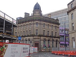
Natwest, Market Street, Bradford, West Yorkshire (one of two in the city centre, the other being close by on Hustlergate). Taken on the afternoon of Saturday the 8th of November 2014. This is the former Bradford District Bank, designed by Eli Milnes.


