Circuit Paul Ricard
 | |
|---|---|
| Formel 1 | |
| Evenemang | Frankrikes Grand Prix |
| Banlängd | |
| 1971-1985 | 5,810 km |
| 1986-1990 | 3,813 km |
| Banrekord | |
| 1971-1985 | 1:39,914 Keke Rosberg, Williams-Honda, 1985 |
| 1986-1990 | 1:08,012 Nigel Mansell, Ferrari, 1990 |
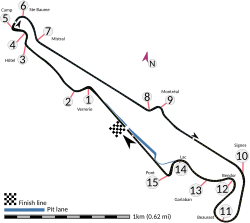
Circuit Paul Ricard eller Circuit du Castellet är en racerbana i Le Castellet i Frankrike. Här kördes Frankrikes Grand Prix i formel 1 mellan 1971 och 1990. Numera används banan till olika tester av F1-bilar. Banan blev dock 2018 åter hem för Frankrikes formel 1-lopp[1].
F1-vinnare
Källor
- ^ ”2018 F1 calendar formally confirmed” (på engelska). Formula 1 - The Official F1 Website. Arkiverad från originalet den 8 december 2017. https://web.archive.org/web/20171208111341/https://www.formula1.com/en/latest/headlines/2017/12/2018-f1-calendar-formally-confirmed.html. Läst 12 december 2017.
Externa länkar
Media som används på denna webbplats
Författare/Upphovsman: HumanBodyPiloter5, Licens: CC0
This is a version of File:Le Castellet circuit map Formula One 2019 and 2021 without corner names English June 2019.svg with corner names added, for contexts where that may be considered useful. This is an altered version of File:Le Castellet circuit map Formula One 2018 without corner names June 2021.svg with the key solely in English and a few other alterations. This is a map of the Le Castellet motor circuit as it was used by w:en:Formula One for the w:en:2019 French Grand Prix and the w:en:2021 French Grand Prix, after the pit lane entrances and exits were reconfigured, and includes corner numbers and other information sourced from the FIA's map of the circuit. This map is valid for races which use this layout and corner numbering scheme, please upload a new file for races which use different layouts or corner numbering schemes rather than replacing this file. As this is a free-hand map drawn by an enthusiast rather than a professional cartographer's work it may contain some errors, although checking it against other maps it appears accurate enough for most purposes. The track is shown in black with a grey outline, while the pit lane is shown in blue. A scale showing the length of one kilometre (with increments of 100 metres) is given, to allow viewers to contextualise and understand what they are looking at. Corner numbers and other important text is given an off-white background to avoid transparency issues rendering it illegible on certain devices. A thick white line covering the track and the pit lane, marked with a chequered flag, shows the location of the start/finish line, also known as the control or timing line. A thinner white line, covering only the track, shows the location of pole position, and is marked with a large black arrow indicating the direction of travel. There are also thin white lines crossing the track which indicate the ends of the first and second timing sectors used by Formula One; these are marked with smaller black arrows, which also indicate the direction of travel. The mauve arrow marked "N" shows the direction of north. Corner names are sourced from the venue's web-site.
- First and second corners: Verrerie
- Third and fourth corners: Hôtel
- Fifth corner: Camp
- Sixth corner: Ste Baume
- Seventh corner leads onto the Mistral Straight
- Eighth and ninth corners form the Montréal chicane
- Tenth corner: Signes
- Eleventh corner: Beausset
- Twelfth corner: Bendor
- Thirteenth corner: Garlaban
- Fourteenth corner: Lac
- Fifteenth corner: Pont
- Arrow pointing north
- Pit lane
- Links corner number to location of corner
- Used to mark centreline of first sector (visible at higher resolutions)
- Used to mark centreline of middle sector (visible at higher resolutions)
- Used to mark centreline of final sector (visible at higher resolutions)

