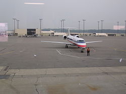
Cincinnati/Northern Kentucky International Airport
| Cincinnati/Northern Kentucky Airport | |||||||||||||||||||||||
 | |||||||||||||||||||||||
| Allmän information | |||||||||||||||||||||||
|---|---|---|---|---|---|---|---|---|---|---|---|---|---|---|---|---|---|---|---|---|---|---|---|
| Flygplatstyp | Internationell flygplats | ||||||||||||||||||||||
| IATA-kod | CVE | ||||||||||||||||||||||
| ICAO-kod | KCVE | ||||||||||||||||||||||
| Öppningsår | 1947 | ||||||||||||||||||||||
| Höjd över havet | 273 meter | ||||||||||||||||||||||
| Koordinater | 39°2′56″N 84°40′4″V / 39.04889°N 84.66778°V | ||||||||||||||||||||||
| Banor | |||||||||||||||||||||||
| |||||||||||||||||||||||
Cincinnati/Northern Kentucky Airport (IATA: CVE, ICAO: KCVE),[1] ibland kallad Greater Cincinnati Airport, är Cincinnatis och norra Kentuckys huvudflygplats. Den största operatören är Delta Air Lines som hade en hubb där till 2017.
Flygplatsen, som öppnade 1947, ligger 13 kilometer sydväst om Cincinnatis centrum. Den är USA:s fjärde största fraktflygplats (2017)[2] och fraktflygbolagen Amazon Air och Southern Air, som flyger för DHL, har sina baser på flygplatsen.
Källor
- ^ ”Cincinnati Northern Kentucky International Airport (CVG)” (på engelska). https://www.world-airport-codes.com/united-states/cincinnati-northern-kentucky-international-1501.html. Läst 8 februari 2021.
- ^ ”Cincinnati, OH: Cincinnati/ Northern Kentucky International (CVG)” (på engelska). Bureau of Transportation Statistics. http://www.transtats.bts.gov/airports.asp?pn=1&Airport=CVG&Airport_Name=Cincinnati. Läst 9 februari 2021.
Externa länkar
- Cincinnati/Northern Kentucky International Airport
 Wikimedia Commons har media som rör Cincinnati/Northern Kentucky International Airport.
Media som används på denna webbplats
Författare/Upphovsman: Ubi Desperare Nescio, Licens: CC BY-SA 2.0
Ariel View of CVG from East
(c) Raghu9 from en.wikipedia.org, CC BY-SA 3.0
An image of the en:American Eagle as seen from Terminal 2 taken on morning of July 1, 2004. I am the author, creator and taker of this image
Författare/Upphovsman: Alexrk2, Licens: CC BY 3.0
Den här Det karta skapades med GeoTools.
Icon-type silhouette of an airplane. (Mainly to be used in Userboxes)


