Chester, West Virginia
| Chester | |
| Stad (city) | |
| Land | |
|---|---|
| Delstat | |
| County | Hancock County |
| Höjdläge | 215 m ö.h. |
| Koordinater | 40°36′46″N 80°33′46″V / 40.61278°N 80.56278°V |
| Area | 2,59 km² (2010)[1] |
| Folkmängd | 2 208 (2020)[2] |
| Befolkningstäthet | 853 invånare/km² |
| Tidszon | EST (UTC-5) |
| - sommartid | EDT (UTC-4) |
| ZIP-kod | 26034 |
| Riktnummer | 304 |
| GNIS-kod | 1537260 |
| Geonames | 5280161 |
Översiktskarta | |
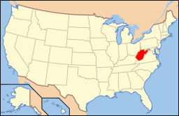
West Virginias läge i USA | |
| Wikimedia Commons: Chester, West Virginia | |
| Webbplats: http://chesterwv.org/ | |
| Redigera Wikidata | |
Chester är en ort i Hancock County i delstaten West Virginia, USA.
Referenser
- ^ United States Census Bureau, 2010 U.S. Gazetteer Files, United States Census Bureau, 2010, läst: 9 juli 2020.[källa från Wikidata]
- ^ United States Census Bureau (red.), USA:s folkräkning 2020, läs online, läst: 1 januari 2022.[källa från Wikidata]
Media som används på denna webbplats
Title: Teapot building, Chester, West Virginia
Physical description: 1 photograph : color transparency ; 35 mm (slide format).
Notes: Forms part of: John Margolies Roadside America photograph archive (1972-2008).; Margolies category: Gift shop signs.; General information about the John Margolies Roadside America photograph archive is available at http://hdl.loc.gov/loc.pnp/pp.mrg; Credit line: John Margolies Roadside America photograph archive (1972-2008), Library of Congress, Prints and Photographs Division.; Title, date and keywords based on information provided by the photographer.; Purchase; John Margolies 2008 (DLC/PP-2008:109-4).Författare/Upphovsman: This version: uploader
Base versions this one is derived from: originally created by en:User:Wapcaplet, Licens: CC BY 2.0
Map of USA with West Virginia highlighted
Författare/Upphovsman: The original uploader was Seth Ilys på engelska Wikipedia., Licens: CC BY-SA 3.0
Adapted from Wikipedia's WV county maps by Seth Ilys.


