Charleville, Irland
| Charleville | |
| Ráth Luirc | |
| Stad | |
(c) John Salter, CC BY-SA 2.0 | |
| Land | |
|---|---|
| Delstat | Munster |
| Indelning | Cork (grevskap) |
| Höjdläge | 100 m ö.h. |
| Koordinater | 52°21′24″N 8°41′04″V / 52.35667°N 8.68444°V |
| Folkmängd | 3 672 (2011)[1] |
| Geonames | 2965516 |
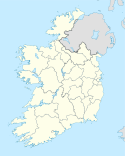
Charleville läge på Irland | |

Charleville eller Ráth Luirc (iriska: Ráth Luirc eller An Ráth) är en ort i norra Cork i Republiken Irland, belägen på Irlands Golden Vale nära gränsen till grevskapet Limerick. Charleville är den näst största staden mellan Cork och Limerick (Mallow är den största) och ligger vid vägen N20. År 2006 hade staden 2 984 invånare.
Källor
- ^ ”Census 2011 – Volume 1 – Population Classified by Area” (PDF). Central Statistics Office Census 2011 Reports. Central Statistics Office Ireland. 1 april 2012. http://www.cso.ie/en/media/csoie/census/documents/census2011vol1andprofile1/Census%202011%20-%20Population%20Classified%20by%20Area.pdf. Läst 10 augusti 2012.
Externa länkar
 Wikimedia Commons har media som rör Charleville.
Media som används på denna webbplats
Shiny red button/marker widget. Used to mark the location of something such as a tourist attraction.
Författare/Upphovsman: NordNordWest, Licens: CC BY-SA 3.0
Location map of Ireland
Författare/Upphovsman: James Corbett, Licens: CC BY-SA 2.0
Charleville railway station, County Cork, Ireland


