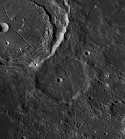
Chacornac (månkrater)
- För andra betydelser, se Chacornac.
| Månkrater | ||
|---|---|---|
| Chacornac | ||
 | ||
| Egenskaper | ||
| Latitud Longitud | ||
| Medeldiameter | 50.44 km | |
| Djup | 1.5 km | |
| Kolongitud | 329° vid soluppgång | |
| Eponym | Jean Chacornac | |
| Kartposition | ||
| Månen - Selenografi - ( ) | ||
Chacornac är en nedslagskrater på månen. Chacornac har fått sitt namn efter den franske astronomen Jean Chacornac.
Satellitkratrar
| Chacornac | Latitud | Longitud | Diameter |
|---|---|---|---|
| A | 29.8° N | 31.5° Ö | 5 km |
| B | 29.8° N | 31.9° Ö | 6 km |
| C | 30.8° N | 32.6° Ö | 4 km |
| D | 30.6° N | 33.6° Ö | 26 km |
| E | 29.4° N | 33.7° Ö | 22 km |
| F | 29.2° N | 32.9° Ö | 26 km |
Se även
Källor
- ”Chacornac on Moon” (på engelska). International Astronomical Union. 18 oktober 2010. https://planetarynames.wr.usgs.gov/Feature/1117. Läst 2 december 2023.
Media som används på denna webbplats
Cráter Chacornac LROC
Red dot, based on the image on en:.
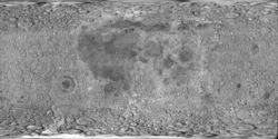
cylindrical map projection of the Moon. The Moon's whole surface was mapped by the Clementine spacecraft in 1994, here North is at the top. The dark floor of crater Plato is at the middle top above Mare Imbrium, while the bright floor and rays of crater Tycho is near the middle bottom below Mare Imbrium. Mare Procellarum is at the near left, and Mare Tranquillitatis is just right of centre and Mare Crisium is at the near right. The far left and far right show the contrast of the mostly cratered farside with small isolated mare.
(c) Gregory H. Revera, CC BY-SA 3.0
Full Moon photograph taken 10-22-2010 from Madison, Alabama, USA. Photographed with a Celestron 9.25 Schmidt-Cassegrain telescope. Acquired with a Canon EOS Rebel T1i (EOS 500D), 20 images stacked to reduce noise. 200 ISO 1/640 sec.


