Chūō, Tokyo
| Chūō (中央区) | |
| Stadsdelskommun | |
| Land | |
|---|---|
| Region | Kantō |
| Prefektur | Tokyo |
| Koordinater | 35°40′N 139°46′Ö / 35.667°N 139.767°Ö |
| Area | 10,21 km²[1] |
| Folkmängd | 172 461 (1 okt 2022)[1] |
| Befolkningstäthet | 16 891 invånare/km² |
| Borgmästare | Yasuto Yamamoto (2019–) |
| Geonames | 1864487 |
| Träd | Videsläktet[2] |
| Blomma | Rododendronsläktet[2] |
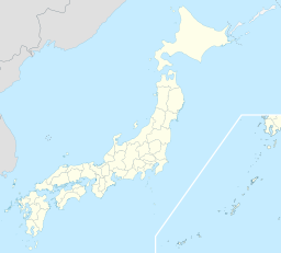
 Chūōs läge i Japan | |
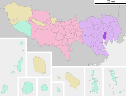
Chuos läge i Tokyo prefektur | |
| Webbplats: Chuo | |

Chūō (japanska: 中央区, Chūō-ku) är en stadsdelskommun i Tokyo. Här ligger bland annat den gamla myntslagarstadsdelen och numera affärsdistriktet Ginza och Nihonbashi som är startpunkt i det japanska vägnätet.
Distrikt i Chūō
- Hakozakicho (箱崎町)
- Hamacho (浜町)
- Hisamatsucho (久松町)
- Higashi Nihonbashi (東日本橋)
- Honcho (本町)
- Hongokucho (本石町)
- Horidomecho (堀留町)
- Kabutocho (兜町)
- Kakigaracho (蛎殻町)
- Kayabacho (茅場町)
- Kodenmacho (小伝馬町)
- Muromachi (室町)
- Nihonbashi (日本橋)
- Ningyocho (人形町)
- Ohdenmacho (大伝馬町)
- Tomizawacho (富沢町)
- Yokoyamacho (横山町)
- Akashicho (明石町)
- Ginza (銀座)
- Hatchobori (八丁堀)
- Hamarikyu-teien (浜離宮庭園)
- Kyōbashi (京橋)
- Minato (湊)
- Shinkawa (新川)
- Shintomi (新富)
- Tsukiji (築地)
- Yaesu (八重洲)
- Harumi (晴海)
- Kachidoki (勝どき)
- Tsukishima (月島)
- Tsukuda (佃)
- Toyomicho (豊海町)
Källor
- ^ [a b] ”東京都の市区町村 Kommuner i Tokyo prefektur”. Masahiro Higashide. https://uub.jp/cty/tokyo.html. Läst 5 mars 2023.
- ^ [a b] läs online, www.city.chuo.lg.jp.[källa från Wikidata]
Media som används på denna webbplats
Shiny red button/marker widget. Used to mark the location of something such as a tourist attraction.
Författare/Upphovsman: Lincun, Licens: CC BY-SA 3.0
Location of Chuo-ku in Tokyo Prefecture
Författare/Upphovsman: Mniz, Licens: CC BY 2.0
Open street for walkers (Hokōsya-Tengoku) on holiday at Chuou-dori Ginza, Tokyo
Författare/Upphovsman: Maximilian Dörrbecker (Chumwa), Licens: CC BY-SA 3.0
Location map of Japan
Equirectangular projection.
Geographic limits to locate objects in the main map with the main islands:
- N: 45°51'37" N (45.86°N)
- S: 30°01'13" N (30.02°N)
- W: 128°14'24" E (128.24°E)
- E: 149°16'13" E (149.27°E)
Geographic limits to locate objects in the side map with the Ryukyu Islands:
- N: 39°32'25" N (39.54°N)
- S: 23°42'36" N (23.71°N)
- W: 110°25'49" E (110.43°E)
- E: 131°26'25" E (131.44°E)


