Châteauneuf-Grasse
| Châteauneuf-Grasse | |
| Kommun | |
 | |
| Land | |
|---|---|
| Region | Provence-Alpes-Côte d'Azur |
| Departement | |
| Arrondissement | Grasse |
| Kanton | Le Bar-sur-Loup |
| Koordinater | 43°41′N 6°59′Ö / 43.683°N 6.983°Ö |
| Yta | 8,95 km²[1] |
| Folkmängd | 3 765 ()[2] |
| Befolkningstäthet | 421 invånare/km² |
| Borgmästare | Emmanuel Delmotte (2020–)[3] |
| Tidszon | CET (UTC+1) |
| - sommartid | CEST (UTC+2) |
| Postnummer | 06740 |
| INSEE | 06038 |
| Geonames | 3026256 |
| OSM-karta | 156344 |
 Kommunens läge i regionen Provence-Alpes-Côte d'Azur i Frankrike. | |
| Webbplats: http://www.ville-chateauneuf.fr | |

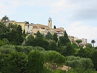
Châteauneuf-Grasse är en kommun i departementet Alpes-Maritimes i regionen Provence-Alpes-Côte d'Azur i sydöstra Frankrike. Kommunen ligger i kantonen Le Bar-sur-Loup som ligger i arrondissementet Grasse. År 2022 hade Châteauneuf-Grasse 3 765 invånare.
Befolkningsutveckling
Antalet invånare i kommunen Châteauneuf-Grasse
Referens: INSEE[4]
Galleri


 Église Notre-Dame-du-Brusc

Se även
Källor
- ^ Répertoire géographique des communes, Institut national de l'information géographique et forestière, läst: 26 oktober 2015.[källa från Wikidata]
- ^ Populations légales 2022, Institut National de la Statistique et des Études Économiques, 19 december 2024.[källa från Wikidata]
- ^ Répertoire national des élus du 2 décembre 2020, 2 december 2020.[källa från Wikidata]
- ^ Chiffres clés - Évolution et structure de la population Arkiverad 5 juli 2012 hämtat från the Wayback Machine.
Media som används på denna webbplats

Författare/Upphovsman: Eric Gaba (Sting - fr:Sting), Licens: CC BY-SA 4.0
Blank physical map of metropolitan France for geo-location purpose.
Scale : 1:14 816 000 (accuracy : about 3,7 km) for the bathymetry. More maps of France, view → Commons Atlas of France.

Shiny red button/marker widget. Used to mark the location of something such as a tourist attraction.

Författare/Upphovsman: MOSSOT, Licens: CC BY-SA 3.0
Det här byggnadsverket är klassificerat som historiskt monument (classé Monument Historique) i Frankrike. Det finns med i base Mérimée, Frankrikes kulturministeriums databas över den franska arkitekturens kulturarv, under referensen PA00080703

Författare/Upphovsman: MOSSOT, Licens: CC BY 3.0
Châteauneuf-Grasse - Rue du Presbytère et clocher de l'église
Författare/Upphovsman:
|
Map data (c) OpenStreetMap contributors, CC-BY-SA _French_municipality_map.svg) • Shape files infrastructure: railway, highways, water: all originally by OpenStreetMap contributors. Status december 2011 *note: shown commune boundaries are from OSM dump May 2012; at that time about 90% complete |
Map commune FR insee code 06038.png

Författare/Upphovsman: MOSSOT, Licens: CC BY 3.0
Châteauneuf-Grasse - Place de la Vieille-Mairie

Författare/Upphovsman: MOSSOT, Licens: CC BY 3.0
Vue sur le massif de l'Estérel et la rade de Cannes depuis Châteauneuf-Grasse

Författare/Upphovsman: Ipankonin, Licens: CC BY-SA 3.0
Coat of arms of the counts of the County of Nice, and the current Alpes-Maritimes Department: Argent, an eagle displayed crowned gules standing upon three rocks vert issuing from the sea azure in base.

Författare/Upphovsman: MOSSOT, Licens: CC BY 3.0
Châteauneuf-Grasse - Eglise Saint-Martin, rue de l'Eglise
Författare/Upphovsman: Christophe Jacquet, Licens: CC BY-SA 2.5
Châteauneuf-Grasse Village.