Centralamazonas
| Den här artikeln behöver källhänvisningar för att kunna verifieras. (2024-04) Åtgärda genom att lägga till pålitliga källor (gärna som fotnoter). Uppgifter utan källhänvisning kan ifrågasättas och tas bort utan att det behöver diskuteras på diskussionssidan. |
| Centralamazonas | |
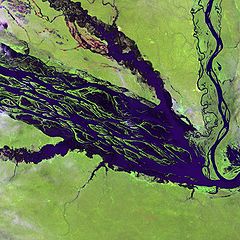
 Floden Negro rinner genom Jaú nationalpark | |
| Geografiskt läge | |
|---|---|
| Koordinater | 2°19′00″S 62°00′30″V / 2.31667°S 62.00833°V |
| Land | Brasilien |
| Region* | Latinamerika och Karibien |
| Data | |
| Kriterier | ix x |
| Referens | 998 |
| Historik | |
| Världsarv sedan | 2000 (24:e mötet) |
. | |
| * Enligt Unescos indelning. | |
Centralamazonas är ett världsarv och är det största skyddade området i Amazonas. Totalt omfattar Centralamazonas 6 miljoner hektar regnskog.
| Område | Upptaget år | Areal (ha) | Andel (%) |
| Amanã | 2003 | 2 350 000 | 45 |
| Anavilhanas | 2003 | 350 018 | 7 |
| Jaús nationalpark | 2000 | 2 272 000 | 43 |
| Mamairauá | 2003 | 260 000 | 5 |
| Samtliga områden | 5 232 018 |
Externa länkar
- UNESCO World Heritage Centre - Central Amazon Conservation Complex
- UNEP World Conservation Monitoring Centre - Jaú National Park
| |||||||||||
Media som används på denna webbplats
Författare/Upphovsman: Tkgd2007, Licens: CC BY-SA 3.0
A new incarnation of Image:Question_book-3.svg, which was uploaded by user AzaToth. This file is available on the English version of Wikipedia under the filename en:Image:Question book-new.svg
Författare/Upphovsman: TUBS
Location map of the world. Equirectangular projection from 180°E to 180°W and from 90°S to 90°N
Shiny red button/marker widget. Used to mark the location of something such as a tourist attraction.
The Negro River flowing through the eastern edge of Brazil’s Jau National Park. The river is the big strip of blue running from left to right across the image, and the other blue ribbons are tributaries. Originating at the border of Venezuela and Brazil, the Negro River meets up with the Amazon in central Brazil to become its largest tributary. Half-submerged islands can be seen in the center of the river. Between November and April when the river is at its peak, many of these islands disappear.
Författare/Upphovsman: Holger.Ellgaard, Licens: CC BY-SA 3.0
Världsarvsflagga vid Falu gruva


