Castleton, Vermont
| Castleton | |
| Kommun (town) | |
| Land | |
|---|---|
| Delstat | |
| County | Rutland County |
| Höjdläge | 198 m ö.h. |
| Koordinater | 43°37′32″N 73°11′36″V / 43.62556°N 73.19333°V |
| Area | 109,7 km²[2] |
| Folkmängd | 4 458 (2020)[3] |
| Befolkningstäthet | 41 invånare/km² |
| Grundad | 1761[1] |
| Tidszon | EST (UTC-5) |
| - sommartid | EDT (UTC-4) |
| ZIP-kod | 05735, 05732 och 05750 |
| Riktnummer | 802 |
| GNIS-kod | 1462065 |
| Geonames | 5281166 |
Översiktskarta | |
Vermonts läge i USA | |
| Wikimedia Commons: Castleton, Vermont | |
| Webbplats: https://www.castletonvermont.org/ | |
| Redigera Wikidata | |
Castleton är en kommun (town) i Rutland County i delstaten Vermont i USA. Vid folkräkningen år 2000 bodde 4 367 personer på orten. Den har enligt United States Census Bureau en area på totalt 109,7 km² varav 8, km² är vatten.
Referenser
- ^ New Hampshire State Papers, vol. 26, 1895, s. 79-82, läs onlineläs online.[källa från Wikidata]
- ^ United States Census Bureau, 2016 U.S. Gazetteer Files, United States Census Bureau, 2016.[källa från Wikidata]
- ^ United States Census Bureau (red.), USA:s folkräkning 2020, läs online, läst: 1 januari 2022.[källa från Wikidata]
| ||||||||||
Media som används på denna webbplats
Författare/Upphovsman: Huebi, Licens: CC BY 2.0
Map of USA with Vermont highlighted
Författare/Upphovsman: The original uploader was Redjar på engelska Wikipedia., Licens: CC BY-SA 3.0
Description: Photograph of the "Old Chapel" in Castleton. The building in the photo was built in 1821. It was used by the Castleton Medical College. It was used as a dormitory, classroom space, and a chapel. The building is registered on the National Register of Historic Places.
Source: Photograph taken by Jared C. Benedict on 01 July 2004.
Copyright: © Jared C. Benedict.Författare/Upphovsman: Jared C. Benedict. (talk) (Uploads), Licens: CC BY-SA 3.0
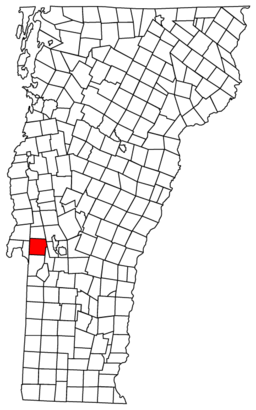
Map of Vermont towns with Castleton highlighted


