Castle Carrock
| Castle Carrock | |
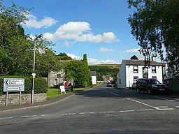
(c) Rose and Trev Clough, CC BY-SA 2.0 Geltsdale Road, Castle Carrock | |
| Land | |
|---|---|
| Riksdel | England |
| Region | Nordvästra England |
| Ceremoniellt grevskap | Cumbria |
| Enhetskommun | Cumberland |
| Koordinater | 54°53′28″N 2°42′54″V / 54.8912°N 2.7149°V |
| Tidszon | GMT (UTC+0) |
| Postnummerområde | CA8 |
| Riktnummer | 01228 |
| Geonames | 2653602 7297580 |
Castle Carrock är en by och en civil parish i Cumbria, England. Orten har 303 invånare (2001).[1] Den har en kyrka.[2]
Referenser
- ^ Neighbourhood statistics Arkiverad 29 oktober 2013 hämtat från the Wayback Machine.
- ^ http://www.britishlistedbuildings.co.uk/en-77996-church-of-st-peter-castle-carrock
Externa länkar
Media som används på denna webbplats
Författare/Upphovsman: Alexrk2, Licens: CC BY-SA 3.0
Location map of the United Kingdom
Shiny red button/marker widget. Used to mark the location of something such as a tourist attraction.
(c) Rose and Trev Clough, CC BY-SA 2.0
Geltsdale Road, Castle Carrock. There used to be two pubs here, on either side of the road. Now there's only one - The Weary Sportsman (known as The Weary) - on the right. The ivy-covered building on the left is 1283979, which has been closed for several years.


