Carmel, New York
| Carmel | |
| town | |
| Land | |
|---|---|
| Delstat | New York |
| County | Putnam County |
| Höjdläge | 197 m ö.h. |
| Koordinater | 41°25′48″N 73°40′48″V / 41.43000°N 73.68000°V |
| Yta | 105,4 km² (2010) |
| - land | 93,5 km² |
| - vatten | 11,9 km² |
| Folkmängd | 33 576 (2020)[1] |
| Befolkningstäthet | 359 invånare/km² |
| Tidszon | EST (UTC-5) |
| - sommartid | EDT (UTC-4) |
| ZIP-kod | 10512, 10541 |
| Riktnummer | 845 |
| FIPS | 3612529 |
| Geonames | 5111576 |
(c) NordNordWest, CC BY 3.0 Ortens läge i delstaten New York | |
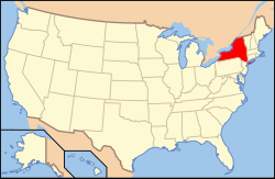
New Yorks läge i USA | |
| Webbplats: http://www.ci.carmel.ny.us/ | |
Carmel är administrativ huvudort i Putnam County i delstaten New York.[2] Enligt 2020 års folkräkning hade Carmel 33 576 invånare.[1]
Källor
- ^ [a b] ”Carmel town, Putnam County, New York 2020 Decennial Census” (på engelska). United States Census Bureau. https://data.census.gov/profile/Carmel_town,_Putnam_County,_New_York?g=0600000US3607912529. Läst 24 januari 2023.
- ^ New York County Map with County Seat Cities. Geology.com Geoscience News and Information. Läst 1 juni 2017.
|
Media som används på denna webbplats
Shiny red button/marker widget. Used to mark the location of something such as a tourist attraction.
Författare/Upphovsman: Huebi, Licens: CC BY 2.0
Map of USA with New York highlighted
Carmel Hamlet seen from Lake Gleneida to the west
(c) NordNordWest, CC BY 3.0
Location map of the State of New York, USA


