Carentan
| Carentan | ||
| Kommun | ||
| ||
| Land | ||
|---|---|---|
| Region | ||
| Departement | ||
| Arrondissement | Saint-Lô | |
| Kanton | Carentan | |
| Koordinater | 49°18′N 1°14′V / 49.300°N 1.233°V | |
| Yta | 15,66 km²[1] | |
| Folkmängd | 5 853 ()[2] | |
| Befolkningstäthet | 374 invånare/km² | |
| Tidszon | CET (UTC+1) | |
| - sommartid | CEST (UTC+2) | |
| Postnummer | 50500 | |
| INSEE | 50099 | |
| Geonames | 3028610 | |
| OSM-karta | 409122 | |
 Kommunens läge i regionen Normandie i Frankrike | ||
| Webbplats: http://www.ville-carentan.fr | ||

Carentan är en kommun i departementet Manche i regionen Normandie i norra Frankrike. Kommunen ligger i kantonen Carentan som tillhör arrondissementet Saint-Lô. År 2018 hade Carentan 5 853 invånare.
Historia
Carentan fick strategisk betydelse under andra världskriget under den så kallade D-dagen, eftersom det var en av de första orterna i Normandie som de allierade styrkorna intog. Det viktiga med denna ort var att det var det enda stället som trupper från Omaha Beach och Utah Beach kunde stråla samman, det var därför orten var lika viktig för tyskarna.
Galleri
- Fallskärmstrupper vid slaget om Normandie
- Amerikansk stridsvagn i Carentan
- Staden befrias av amerikanska trupper
- Amerikansk haubits skjuter granater mot retirerande tyska trupper
- Hyllning till stupad amerikansk soldat
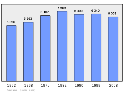
Befolkningsutveckling
Antalet invånare i kommunen Carentan
 Referens: INSEE[3] |
Se även
Källor
- ^ Répertoire géographique des communes, Institut national de l'information géographique et forestière, läst: 26 oktober 2015.[källa från Wikidata]
- ^ Populations légales 2018, Institut National de la Statistique et des Études Économiques, 28 december 2020.[källa från Wikidata]
- ^ Chiffres clés - Évolution et structure de la population hämtat från the Wayback Machine (arkiverat 4 maj 2012).
Externa länkar
 Wikimedia Commons har media som rör Carentan.
Media som används på denna webbplats
Författare/Upphovsman: Eric Gaba (Sting - fr:Sting), Licens: CC BY-SA 4.0
Blank physical map of metropolitan France for geo-location purpose.
Scale : 1:14 816 000 (accuracy : about 3,7 km) for the bathymetry. More maps of France, view → Commons Atlas of France.
Shiny red button/marker widget. Used to mark the location of something such as a tourist attraction.
THE ALLIED CAMPAIGN IN NORTH-WEST EUROPE, 6 JUNE 1944 - 7 MAY 1945
The Battle for Normandy: The French Tricolour floats over a street in Carentan, the first French town to be liberated by the Americans. French civilians wave their hands in welcome as men of the US 7th Corps pass through the streets after two days of bitter fighting The capture of Carentan materially strengthened the link between the two American beachheads.Författare/Upphovsman: Johan N, Licens: CC BY-SA 3.0
The harbour of Carentan, Manche, France
Författare/Upphovsman: Michiel1972, Licens: CC BY-SA 3.0
Population - Municipality code 50099.svg
Population Census 1962-2008Författare/Upphovsman:
|
Map data (c) OpenStreetMap contributors, CC-BY-SA  • Shape files infrastructure: railway, highways, water: all originally by OpenStreetMap contributors. Status december 2011 *note: shown commune boundaries are from OSM dump May 2012; at that time about 90% complete |
Map commune FR insee code 50099.png
Författare/Upphovsman: Den här vektorbilden skapades med Inkscape av v ., Licens: CC BY-SA 3.0
Gules, two lions passant guardant in pale or armed and langued azure, used as the inofficial "coat of arms of Normandy".
Coat of arms attributed to "Arms of William the Conqueror (William I of England)"A self-propelled howitzer M7 Priest of the 14th Armored Field Artillery Battalion of the 2nd Armored Division at the intersection of Holgate Street and the railway line Paris-Cherbourg. Carentan, France
"French civilians erected this silent tribute to an American soldier who has fallen in the crusade to liberate France from German domination. Carentan, France, 06/17/1944".
U.S. Airborne paratroopers in and on a captured VW Kübelwagen and by houses in Carentan, en:Battle of Normandy, 1944.
- General notes: Use War and Conflict Number 1047 when ordering a reproduction or requesting information about this image. [1]
Blason de la ville de Carentan (Manche) : d'argent à l'aigle éployée de gueules, accostée de neuf billettes de même, 4, 2, 2 et 1 ; au chef d'azur chargé de trois fleurs de lys d'or


