Carabietta
| Den här artikeln behöver källhänvisningar för att kunna verifieras. (2020-09) Åtgärda genom att lägga till pålitliga källor (gärna som fotnoter). Uppgifter utan källhänvisning kan ifrågasättas och tas bort utan att det behöver diskuteras på diskussionssidan. |
| Carabietta | |
| Ort | |
Carabietta | |
| Land | |
|---|---|
| Kanton | Ticino |
| Distrikt | Lugano |
| Kommun | Collina d'Oro |
| Höjdläge | 298 m ö.h. |
| Koordinater | 45°58′0″N 8°54′6″Ö / 45.96667°N 8.90167°Ö |
| Folkmängd | 110 (2011) |
| Tidszon | CET (UTC+1) |
| - sommartid | CEST (UTC+2) |
| Postnummer | 6919 |
| Geonames | 8533646 |
| Språk | Italienska |
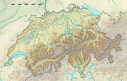
Carabiettas läge i Schweiz | |
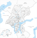
Kommunindelning innan sammanslagningen | |
Carabietta är en ort vid Luganosjön i kommunen Collina d'Oro i kantonen Ticino, Schweiz. Carabietta var tidigare en självständig kommun, men 1 april 2012 blev Carabietta en del av kommunen Collina d'Oro.
Media som används på denna webbplats
Författare/Upphovsman: Tkgd2007, Licens: CC BY-SA 3.0
A new incarnation of Image:Question_book-3.svg, which was uploaded by user AzaToth. This file is available on the English version of Wikipedia under the filename en:Image:Question book-new.svg
Författare/Upphovsman: Eric Gaba (Sting - fr:Sting) and NordNordWest, Licens: CC BY-SA 3.0
Blank physical map of Switzerland, for geo-location purpose. More maps: → Maps of Switzerland.
Shiny red button/marker widget. Used to mark the location of something such as a tourist attraction.
Författare/Upphovsman: Hajo1932, Licens: CC BY-SA 4.0
In the center of the village Carabietta (Canton Ticino / Switzerland)
Författare/Upphovsman: Tschubby, Licens: CC BY-SA 3.0
Municipality Carabietta


