Canton, South Dakota
| Canton | |
| city | |
(c) Jake DeGroot, CC BY-SA 3.0 Byrnes House | |
| Motto: Can Live. Can Dream. Can Do. | |
| Land | |
|---|---|
| Delstat | South Dakota |
| County | Lincoln County |
| Höjdläge | 387 m ö.h. |
| Koordinater | 43°18′3″N 96°35′34″V / 43.30083°N 96.59278°V |
| Yta | 8,34 km² (2010) |
| - land | 8,26 km² |
| - vatten | 0,08 km² |
| Folkmängd | 3 066 (2020)[1] |
| Befolkningstäthet | 371 invånare/km² |
| Tidszon | CST (UTC-6) |
| - sommartid | CDT (UTC-5) |
| ZIP-kod | 57013 |
| Riktnummer | 605 |
| FIPS | 4609500 |
| Geonames | 5226716 |
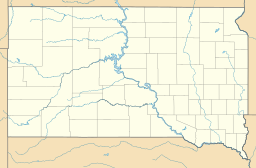
Ortens läge i South Dakota | |
South Dakotas läge i USA | |
| Webbplats: cantonsd.org | |
Canton är administrativ huvudort i Lincoln County i South Dakota.[2][3] Enligt 2020 års folkräkning hade Canton 3 066 invånare.[1]
Kända personer från Canton
- Tim Johnson, politiker
- Ernest Lawrence, fysiker
Källor
- ^ [a b] ”Canton city, South Dakota 2020 Decennial Census” (på engelska). United States Census Bureau. https://data.census.gov/profile/Canton_city,_South_Dakota?g=1600000US4609500. Läst 18 januari 2023.
- ^ South Dakota County Map with County Seat Cities. Geology.com Geoscience News and Information. Läst 16 juni 2017.
- ^ Canton, SD. Map Quest. Läst 16 juni 2017.
Externa länkar
 Wikimedia Commons har media som rör Canton, South Dakota.
|
Media som används på denna webbplats
Shiny red button/marker widget. Used to mark the location of something such as a tourist attraction.
Författare/Upphovsman: Huebi, Licens: CC BY 2.0
Map of USA with South Dakota highlighted
Författare/Upphovsman: Alexrk, Licens: CC BY 3.0
Location map of South Dakota, USA
(c) Jake DeGroot, CC BY-SA 3.0
The Byrnes House in Canton, South Dakota. It is on the National Register of Historic Places.


