Camino Real de Tierra Adentro
| Camino Real de Tierra Adentro | |
 | |
| Geografiskt läge | |
|---|---|
| Koordinater | 22°36′29″N 102°22′45″V / 22.60806°N 102.37917°V |
| Land | |
| Region* | Europa och Nordamerika |
| Data | |
| Typ | Kulturarv |
| Kriterier | ii, iv |
| Referens | 1351 |
| Historik | |
| Världsarv sedan | 2010 (34:e mötet) |
| * Enligt Unescos indelning. | |
Camino Real de Tierra Adentro, oftast bara kallad El Camino Real (även kallad Chihuahua Trail i sin norra sträckning) var en 2560 kilometer lång transportled som förband Santa Fe, New Mexico med Mexico City från 1598 till slutet av 1800-talet.
Enda förbindelsen med New Mexico
Innan Mexiko vann sin självständighet 1821 var alla förbindelser mellan New Mexico och omvärlden begränsad till denna led, som användes av oxkärror och packmulor för att transportera guvernörer, soldater, missionärer och kolonister.
Santa Fe Trail

När Santa Fe Trail hade etablerats fortsatte amerikanska köpmän sina handelsexpeditioner söderut från Santa Fe längs El Camino Real. Denna handelsväg fungerade fram till det att järnvägarna slog igenom i slutet av 1800-talet.
Jornada del Muerto
Jornada del Muerto var den ungefär 200 km långa del av Chihuahua Trail söder om Santa Fe i New Mexico, som gick igenom en ökenbassäng utan vatten.
Bilder
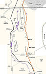
Karta över Jornade del Muerto.

Del av Jornada del Muerto idag.

Vy från Jornada del Muerto idag.

Vy över en del av Camino Reals sträckning.
Litteratur
- Hal Jackson, Following the Royal Road : a guide to the historic Camino Real de Tierra Adentro (Albuquerque : University of New Mexico Press, 2006).
- Hunt Janin & Ursula Carlson, Trails of historic New Mexico : routes used by Indian, Spanish and American travelers through 1886 (Jefferson, N.C. : McFarland, c2010).
- Eniac Martínez, Camino Real de Tierra Adentro (México, D.F. : Instituto Nacional de Antropología e Historia, 2006).
- Max L. Moorehead, New Mexico’s royal road : trade and travel on the Chihuahua Trail (Norman : University of Oklahoma Press, c1995).
Referenser
- Den här artikeln är helt eller delvis baserad på material från engelskspråkiga Wikipedia, El Camino Real de Tierra Adentro, 9 februari 2010.
Externa länkar
- El Camino Real de Tierra Adentro Youtube: New Mexico PBS.
Media som används på denna webbplats


Map of the Jornada del Muerto, New Mexico, USA

Författare/Upphovsman: Samat Jain from New York City, USA, Licens: CC BY-SA 2.0
Looking past the end of the Yost Escarpment Trail, which terminates at the Yost Escarpment. In the distance is the construction site for New Mexico's Spaceport America.
The El Camino Real de Tierra Adentro (Spanish for "The Royal Road of the Interior Land") is an ancient travel route between Santa Fe and Mexico City, whose use started in the late 16th century. The portion that travels through New Mexico passes through an arid desert known as the Jornada del Muerto (Spanish for "Journey of the Dead Man"), within which was recently created a National Historic Trail. Portions of this trail are open for hiking.
Författare/Upphovsman: Samat Jain from New York City, USA, Licens: CC BY-SA 2.0
Looking southeast from the Point of Rocks along El Camino Real de Tierra Adentro. In the immediate valley below lies a railroad that follows much of the trail's original route, and to the far left lies the tail end of the Robledo Mountains northwest of Las Cruces.
The El Camino Real de Tierra Adentro (Spanish for "The Royal Road of the Interior Land") is an ancient travel route between Santa Fe and Mexico City, whose use started in the late 16th century. The portion that travels through New Mexico passes through an arid desert known as the Jornada del Muerto (Spanish for "Journey of the Dead Man"), within which was recently created a National Historic Trail. Portions of this trail are open for hiking.
Seen at:
• The Professor Who Stole Ancient New Mexico Artifacts1845 Santa Fe Trail
Map of Camino Real de Adentro of the Spanish Viceroyalty of New Spain:
- Trail route runs between Mexico City in Colonial Mexico, and Santa Fe and San Juan in Colonial New Mexico (Santa Fe De Nuevo México province).
- Present day nations/borders are shown.

Författare/Upphovsman: Cory Boehne, Licens: CC BY-SA 4.0
Looking South towards the nested splatter cones of the Jornada del Muerto Volcano