Calumet County
| Calumet County | |
| County | |
Sherwood, Calumet County. | |
| Land | |
|---|---|
| Delstat | |
| Huvudort | Chilton |
| Area | 1 028 km² (2010)[1] |
| - land | 824 km² (80%) |
| - vatten | 204 km² (20%) |
| Folkmängd | 48 971 (2010)[2] |
| Befolkningstäthet | 59 invånare/km² |
| Grundat | 1836 |
| Tidszon | CST (UTC-6) |
| - sommartid | CDT (UTC-5) |
| FIPS-kod | 55015 |
| Geonames | 5247444 |
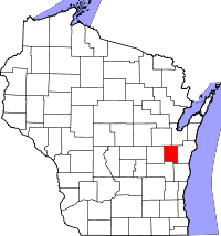
Läge i delstaten Wisconsin. | |
Delstatens läge i USA. | |
Calumet County är ett administrativt område i östra delen av delstaten Wisconsin, USA. År 2010 hade countyt 48 971 invånare. Den administrativa huvudorten (county seat) är Chilton. Countyt är beläget omedelbart öster om sjön Lake Winnebago som (liksom countyt som helhet) är starkt påverkad av den senaste nedisningen.
Calumet County är ett typiskt jordbruksdistrikt och cirka 75 % av marken ägs av jordbrukare. I countyt produceras en betydande del av amerikansk ost.
Geografi
Enligt United States Census Bureau har countyt en total area på 1 028 km². 828 km² av den arean är land och 200 km² är vatten.
Angränsande countyn
- Brown County - nordost
- Manitowoc County - öst
- Sheboygan County - sydost
- Fond du Lac County - sydväst
- Winnebago County - väst
- Outagamie County - nordväst
Större orter
- Brillion med 4 300 invånare
- Chilton – 4 800
- Kiel – 3 500
- Harrison – 5 800
- New Holstein – 3 300
Källor
- ^ ”2010 Census U.S. Gazetteer Files for Counties”. U.S. Census Bureau. Arkiverad från originalet den 5 juli 2012. https://www.webcitation.org/68vYLbou5?url=http://www.census.gov/geo/www/gazetteer/files/Gaz_counties_national.txt. Läst 5 juli 2012.
- ^ ”State & County QuickFacts, Calumet County, Wisconsin” (på engelska). U.S. Census Bureau. Arkiverad från originalet den 8 juli 2011. https://www.webcitation.org/601AF50RZ?url=http://quickfacts.census.gov/qfd/states/55/55015.html. Läst 6 juli 2011.
| ||||||||||
|
Media som används på denna webbplats
This is a locator map showing Calumet County in Wisconsin. For more information, see Commons:United States county locator maps.
Författare/Upphovsman: This version: uploader
Base versions this one is derived from: originally created by en:User:Wapcaplet, Licens: CC BY 2.0
Map of USA with Wisconsin highlighted
Författare/Upphovsman: self, Licens: CC BY-SA 2.5
Looking west at the southwest corner of en:Sherwood, Wisconsin and the north tip of en:Lake Winnebago taken from the observation tower at en:High Cliff State Park in en:Sherwood, Wisconsin, USA.


