Cahors
| Cahors | |||
| Kommun | |||
 | |||
| |||
| Land | |||
|---|---|---|---|
| Region | Occitanien | ||
| Departement | |||
| Arrondissement | Cahors | ||
| Kanton | chef-lieu för 3 kantoner | ||
| Koordinater | 44°26′N 1°26′Ö / 44.433°N 1.433°Ö | ||
| Yta | 64,72 km²[1] | ||
| Folkmängd | 20 141 ()[2] | ||
| Befolkningstäthet | 311 invånare/km² | ||
| Tidszon | CET (UTC+1) | ||
| - sommartid | CEST (UTC+2) | ||
| Postnummer | 46000 | ||
| INSEE | 46042 | ||
| Geonames | 3029213 | ||
| OSM-karta | 122324 | ||
 Kommunens läge i regionen Occitanien i Frankrike | |||
| Webbplats: http://www.mairie-cahors.fr/ | |||

Cahors (occitanska: Caors) är en kommun i departementet Lot i regionen Occitanien i södra Frankrike. Kommunen är chef-lieu över 3 kantoner som tillhör arrondissementet Cahors. År 2021 hade Cahors 20 141 invånare.
Mimaren Marcel Marceau har bott i Cahors.
Befolkningsutveckling
Antalet invånare i kommunen Cahors
 Referens: INSEE[3] |
Galleri
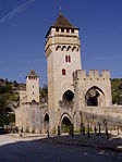
 Pont Valentré
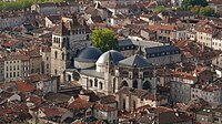

 (c) Sting, CC BY-SA 2.5
Se även
Källor
- ^ Répertoire géographique des communes, Institut national de l'information géographique et forestière, läst: 26 oktober 2015.[källa från Wikidata]
- ^ Populations légales 2021, Institut National de la Statistique et des Études Économiques, 28 december 2023.[källa från Wikidata]
- ^ Chiffres clés - Évolution et structure de la population hämtat från the Wayback Machine (arkiverat 4 maj 2012).
Externa länkar
 Wikimedia Commons har media som rör Cahors.
Media som används på denna webbplats


Shiny red button/marker widget. Used to mark the location of something such as a tourist attraction.
Författare/Upphovsman: Michiel1972, Licens: CC BY-SA 3.0
Population - Municipality code 46042.svg
Population Census 1962-2008.svg)

Författare/Upphovsman: Rastrojo (D•ES) , Licens: CC BY-SA 3.0
Bandera de Cahors - Flag of Cahors - Drapeau de Cahors
Författare/Upphovsman:
|
Map data (c) OpenStreetMap contributors, CC-BY-SA _French_municipality_map.svg) • Shape files infrastructure: railway, highways, water: all originally by OpenStreetMap contributors. Status december 2011 *note: shown commune boundaries are from OSM dump May 2012; at that time about 90% complete |
Map commune FR insee code 46042.png

Författare/Upphovsman: The original uploader was Accrochoc på franska Wikipedia., Licens: CC BY-SA 3.0
Photo du pont Valentré à Cahors prise par Accrochoc le 30 avril 2006

Författare/Upphovsman: Eric Gaba (Sting - fr:Sting), Licens: CC BY-SA 2.5
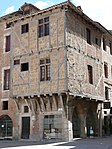
The 15th century Hôtel de Roaldès, also called 'House Henry IV' at Cahors, France.
Författare/Upphovsman: Christophe.Finot, Licens: CC BY-SA 2.5
Cahors, vue du Mont Saint-Cyr, Lot, FRANCE


Författare/Upphovsman: Peter Gugerell, Licens: CC BY-SA 3.0
Cathedral Saint-Étienne, Cahors


Författare/Upphovsman: MOSSOT, Licens: CC BY-SA 3.0
Cahors - 12 rue Daurade
Författare/Upphovsman: Eric Gaba (Sting - fr:Sting), Licens: CC BY-SA 4.0
Blank physical map of metropolitan France for geo-location purpose.
Scale : 1:14 816 000 (accuracy : about 3,7 km) for the bathymetry. More maps of France, view → Commons Atlas of France.