Byeonsan-myeon
| Byeonsan-myeon (변산면) | |
| Socken | |
Gyeokpo hamn | |
| Land | |
|---|---|
| Provins | Norra Jeolla |
| Kommun | Buan-gun |
| Koordinater | 35°39′51″N 126°31′45″Ö / 35.6641°N 126.5291°Ö |
| Area | 86,05 km²[1] |
| Folkmängd | 4 785 (31 dec 2019)[1] |
| Befolkningstäthet | 56 invånare/km² |
| Tidszon | KST (UTC+9) |
| Geonames | 8690738 |
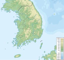
Läge i Sydkorea | |
Byeonsan-myeon (koreanska: 변산면) är en socken i Sydkorea. Den ligger i kommunen Buan-gun i provinsen Norra Jeolla, i den västra delen av landet, 220 km söder om huvudstaden Seoul.
Delar av Byeonsanbando nationalpark ligger i Byeonsan-myeon.
Källor
- ^ [a b] ”2020년 통계연보 (Statistisk årsbok 2020, data per 31 dec 2019)” (på koreanska) (xls). Invånarantal inklusive utländska medborgare. Buan-gun. sid. Kap 2 토지 및 기후 (Yta), Kap 3 인구 (Befolkning). https://www.buan.go.kr/board/list.buan?boardId=BBS_0000091&menuCd=DOM_000000105009002001&contentsSid=648&cpath=. Läst 29 november 2021.
Media som används på denna webbplats
Författare/Upphovsman: User:Urutseg, Licens: CC0
Stretched version of South Korea physical map.svg in order to be compatible with File:South Korea location map.svg
Shiny red button/marker widget. Used to mark the location of something such as a tourist attraction.
Författare/Upphovsman: Steve46814, Licens: CC BY-SA 4.0
Gyeokpo Port/Harbor is a tourist destination and a first class port linking islands on the West Coast like Wido and Gogunsangundo. In the past Gyeokpo Harbor was a base for naval forces. A chief for the navy forces and government officials were assigned here during the Joseon Dynasty.


