Buskerud fylke
| Buskerud fylke | |||
| Buskerud | |||
| Fylke | |||
Villa Fridheim i Krødsherad. | |||
| |||
| Land | |||
|---|---|---|---|
| Koordinater | 60°30′N 9°30′Ö / 60.500°N 9.500°Ö | ||
| Residensstad | Drammen | ||
| Högsta punkt | Folarskardnuten | ||
| - höjdläge | 1 933 m ö.h. | ||
| - koordinater | 60°36′36″N 7°43′22″Ö / 60.61000°N 7.72278°Ö | ||
| Area | 15 053,83 km² (2018)[2] | ||
| - land | 14 912,19 km² (2018)[2] | ||
| - vatten | 1 276,15 km² (2018) | ||
| Folkmängd | 283 148 (2019)[3] | ||
| Befolkningstäthet | 19 invånare/km² | ||
| Grundad | |||
| - Ersätter | Viken fylke | ||
| Ledare | |||
| - Fylkesordförande | Roger Ryberg (2015–) (Ap)[1] | ||
| Tidszon | CET (UTC+1) | ||
| - sommartid | CEST (UTC+2) | ||
| ISO 3166-2 | NO-33 | ||
| Geonames | 3159665 | ||
(c) Karte: NordNordWest, Lizenz: Creative Commons by-sa-3.0 de Fylkets läge i Norge | |||
| Wikimedia Commons: Buskerud | |||
| Webbplats: http://www.bfk.no | |||
| Redigera Wikidata | |||


Buskerud fylke är ett norskt fylke, som gränsar mot Akershus, Oslo, Innlandet, Vestland, Telemark och Vestfold.

Högsta punkten är Folarskardnuten (1933 meter) i Hols kommun. En majoritet av fylkets invånare bor i Drammenregionen och 101 995 invånare (2012) bor i den kommungränsöverskridande tätorten Drammen.

Trillemarka - Rollagsfjells naturreservat finns i kommunerna Sigdal, Nore och Uvdal och Rollag i Buskerud fylke. Reservatet är det största sammanhängande naturskogsområdet i Sydnorge. [4]
Fylket upphörde den 1 januari 2020 då Viken fylke bildades genom sammanslagning av Østfold fylke, Akershus fylke och Buskerud fylke. Viken fylke upplöstes den 1 januari 2024 och Buskerud fylke återupprättades.[5]
Kommuner
- Drammens kommun
- Flesbergs kommun
- Flå kommun
- Gols kommun
- Hemsedals kommun
- Hols kommun
- Hole kommun
- Kongsbergs kommun
- Krødsherads kommun
- Liers kommun
- Modums kommun
- Nesbyens kommun
- Nore og Uvdals kommun
- Ringerike kommun
- Rollags kommun
- Sigdals kommun
- Åls kommun
- Øvre Eikers kommun
Fylkets tätorter kommunvis
|
|
Städer
I Buskerud fylke finns fem städer:[6]
Referenser
- ^ Fylkesordfører (på norskt bokmål), läs online, läst: 13 november 2019.[källa från Wikidata]
- ^ [a b] Arealstatistikk for Norge (på norskt bokmål), Statens kartverk, 27 februari 2018, läs online.[källa från Wikidata]
- ^ Population and changes during the quarter (M) 1997K4 - 2019K2 (på engelska), läs online, läst: 17 november 2019.[källa från Wikidata]
- ^ - En seier for skogen, Dagbladet. Publicerat 8 januari 2008. Läst den 28 maj 2018.
- ^ Regjeringen.no
- ^ Store norske leksikon
| ||||||||||
| ||||||||||
Media som används på denna webbplats
Författare/Upphovsman: Gutten på Hemsen, Licens: CC0
Flag of Norway with colors from the previous version on Commons. This file is used to discuss the colors of the Norwegian flag.
Kommunevåpen for Flesberg kommune i Buskerud fylke.
Författare/Upphovsman:
Hallvard Trætteberg, vectorization by VulpesVulpes42
⸻
(Authorship information for the oldest file version:)
Coat of arms by SKvalen (PD-Norwegian CoA)
SVG flag by SiBr4, Licens: CC BY-SA 3.0
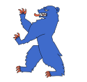
The flag of the county of Buskerud, Norway. Its design is shared with the county arms, and shows a blue bear, constituting an expression of Buskerud's vast expanses of mountains and forests, among which Vassfaret in particular has been known for its populations of bears. The ursine's striking colouration is a reference to the Blue Colour Works in Modum, where cobalt ore was mined, and blue pigment produced from it. For a time, the works were the largest of their kind in the world—the fruits therefrom once made up 80% of the global market, and constituted a pertinent export.
The white background of the flag carries symbolism too. Within heraldry, it is permissible to use white to depict silver, and on flags, this is even customary. Here, a white/silver background is used to represent the Kongsberg Silver Mines, and their massive mineral riches—operating between 1623 and 1957, their history spanned over 300 years. The flag was approved by royal resolution 1966‐04‐01.
Kommunevåpen for Sigdal kommune i Buskerud fylke.
Kommunevåpen for Nes kommune i Buskerud fylke.
Hallingskarvet national park seen from south. The picture is taken from the mountain Store Grønenuten at Hardangervidda.
Kommunevåpen for Drammen kommune i Buskerud fylke.
Kommunevåpen for Hole kommune i Buskerud fylke.
Kommunevåpen for Nore og Uvdal kommune i Buskerud fylke.
Författare/Upphovsman: Arnstein Rønning, Licens: CC BY-SA 3.0
Jonsknuten (Knuten) i Kongsberg kommune. 904 moh. You are free to use this picture outside Wikipedia (see license), as long as you write: Photo: Arnstein Rønning
Skier scouting the terrain near Langseterfjell in Trillemarka-Rollagsfjell, Norway
Författare/Upphovsman: John Erling Blad, Licens: CC BY-SA 2.5
Villa Fridheim i Krødsherad oppført i årene 1890- 1892 tegnet av arkitekt no:Herman Major Backer.
Coat of arms for Buskerud county (fylke), Norway.
(c) Karte: NordNordWest, Lizenz: Creative Commons by-sa-3.0 de
Location of county Buskerud in Norway (2024)
Kommunevåpen for Flå kommune i Buskerud fylke.
Kommunevåpen for Hol kommune i Buskerud fylke.
Kommunevåpen for Kongsberg kommune i Buskerud fylke.
Kommunevåpen for Hemsedal kommune i Buskerud fylke.
Kommunevåpen for Rollag kommune i Buskerud fylke.
Kommunevåpen for Krødsherad kommune i Buskerud fylke.
Författare/Upphovsman: BKP, Licens: CC BY-SA 3.0
Main Street in the city Gol in Norway. July 10, 1993.


