Buntingford
| Buntingford | |
Buntingford | |
| Land | |
|---|---|
| Riksdel | England |
| Region | Östra England |
| Ceremoniellt grevskap | Hertfordshire |
| Administrativt grevskap | Hertfordshire |
| Distrikt | East Hertfordshire |
| Koordinater | 51°56′44″N 0°01′04″V / 51.94556°N 0.01778°V |
| Tidszon | GMT (UTC+0) |
| Postnummerområde | SG9 |
| Riktnummer | 01763 |
| Geonames | 2654323 7295802 |
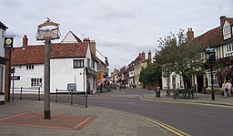
Buntingford är en ort och civil parish i distriktet East Hertfordshire i Hertfordshire, England. Den ligger längs floden Rib och den romerska vägen Ermine Street. Buntingford består till stor del av ett antal gregorianska och medeltida byggnader.
Media som används på denna webbplats
Författare/Upphovsman: Alexrk2, Licens: CC BY-SA 3.0
Location map of the United Kingdom
Shiny red button/marker widget. Used to mark the location of something such as a tourist attraction.
Författare/Upphovsman: Traveler100, Licens: CC BY-SA 3.0
Buntingford in Hertfordshire


