Broughton and Bretton
| Broughton and Bretton (Brychdyn a Bretton) | |
| Community | |
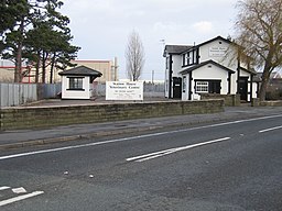
(c) John S Turner, CC BY-SA 2.0 Före detta järnvägsstationen Broughton and Bretton (nedlagd 1964) | |
| Land | |
|---|---|
| Riksdel | Wales |
| Kommun | Flintshire |
| Koordinater | 53°10′07″N 2°59′03″V / 53.1686°N 2.9841°V |
| Area | 12,3 km² |
| Folkmängd | 5 974 (2011)[1] |
| Befolkningstäthet | 486 invånare/km² |
| Tidszon | UTC (UTC+0) |
| - sommartid | BST (UTC+1) |
| Geonames | 7292368 |
Läge i Storbritannien | |
Broughton and Bretton är en community i Storbritannien.[1] Den ligger i kommunen Flintshire och riksdelen Wales, i den södra delen av landet, 260 km nordväst om huvudstaden London.
Här finns flygplatsen Hawarden med en av Airbus flygplansfabriker. Största orten är Broughton.
Källor
- ^ [a b] ”Broughton and Bretton Parish”. Office for National Statistics. https://www.nomisweb.co.uk/reports/localarea?compare=W04000180. Läst 22 juli 2022.
Media som används på denna webbplats
Författare/Upphovsman: Alexrk2, Licens: CC BY-SA 3.0
Location map of the United Kingdom
Shiny red button/marker widget. Used to mark the location of something such as a tourist attraction.
(c) John S Turner, CC BY-SA 2.0
The Redundant Broughton and Bretton Railway Station This station was on the Mold Junction railway line from Chester to Mold, and when it was opened in 1849 it was called Broughton. The name was changed to Broughton Hall in 1861, and then changed again in 1908 to Broughton and Bretton. The line crossed the A5104 Chester Road at this point with a level crossing. The station house is on the right and is shown on the 1882 O.S. map as Broughton Hall Station. The small building on the left was the waiting room for Chester bound passengers. The area between the buildings is now the car park for the veterinary centre.


