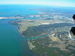
Brisbane Airport
| Den här artikeln behöver källhänvisningar för att kunna verifieras. (2017-07) Åtgärda genom att lägga till pålitliga källor (gärna som fotnoter). Uppgifter utan källhänvisning kan ifrågasättas och tas bort utan att det behöver diskuteras på diskussionssidan. |
| Brisbane Airport | |||||||||||||||||||
 | |||||||||||||||||||
| Allmän information | |||||||||||||||||||
|---|---|---|---|---|---|---|---|---|---|---|---|---|---|---|---|---|---|---|---|
| Ort | West Beach, South Australia | ||||||||||||||||||
| Land | Australien | ||||||||||||||||||
| Flygplatstyp | Internationell flygplats | ||||||||||||||||||
| IATA-kod | BNE | ||||||||||||||||||
| ICAO-kod | YBBN | ||||||||||||||||||
| Ägare | Leasad federal flygplats | ||||||||||||||||||
| Driftbolag | Brisbane Airport Corporation Pty Limited | ||||||||||||||||||
| Höjd över havet | 4 m | ||||||||||||||||||
| Koordinater | 27°23′00″S 153°07′05″Ö / 27.38333°S 153.11806°Ö | ||||||||||||||||||
| Officiell webbplats | www.bne.com.au | ||||||||||||||||||
| Banor | |||||||||||||||||||
| |||||||||||||||||||
| Statistik | |||||||||||||||||||
| Passagerare (2013/14) | 22 092 271[1][2] | ||||||||||||||||||
| Landningar (2013/14) | 198 996 | ||||||||||||||||||
Brisbane Airport (IATA: BNE, ICAO: YBBN) är en flygplats belägen i Brisbane och är Australiens tredje största flygplats. Flygplatsen tjänar som hub för flygbolagen Virgin Blue och Pacific Blue.
Referenser
Noter
- ^ ”Domestic aviation activity” (på engelska). BITRE. Arkiverad från originalet den 2 april 2015. https://web.archive.org/web/20150402073000/http://www.bitre.gov.au/publications/ongoing/files/domestic_airline_activity_2013_2014.pdf. Läst 3 november 2014.
- ^ ”International aviation activity” (på engelska). BITRE. Arkiverad från originalet den 3 november 2014. https://web.archive.org/web/20141103030753/http://www.bitre.gov.au/publications/ongoing/files/International_airline_activity_FY2014.pdf. Läst 3 november 2014.
Webbkällor
Media som används på denna webbplats
Författare/Upphovsman: Tkgd2007, Licens: CC BY-SA 3.0
A new incarnation of Image:Question_book-3.svg, which was uploaded by user AzaToth. This file is available on the English version of Wikipedia under the filename en:Image:Question book-new.svg
Författare/Upphovsman: , Licens: CC BY-SA 3.0
Relief map of Australia, including the borders of the states of the Commonwealth of Australia
Icon-type silhouette of an airplane. (Mainly to be used in Userboxes)


