Brännland, Bjurholms kommun
| Brännland | |
| By | |
| Land | |
|---|---|
| Landskap | Ångermanland |
| Län | Västerbottens län |
| Kommun | Bjurholms kommun |
| Distrikt | Bjurholms distrikt |
| Koordinater | 63°52′4″N 19°27′39″Ö / 63.86778°N 19.46083°Ö |
| Tidszon | CET (UTC+1) |
| - sommartid | CEST (UTC+2) |
| Postort | Bjurholm |
| Postnummer | 916 91 |
| Riktnummer | 0932 |
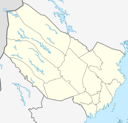
Brännlands läge i Västerbottens län. | |
Brännland är en by i Bjurholms distrikt (Bjurholms socken) i Bjurholms kommun, Västerbottens län (Ångermanland). För att skilja byn från Brännland, Umeå kommun kallas ofta byn för Bjurholms-Brännland.
Media som används på denna webbplats
Författare/Upphovsman: Erik Frohne, Licens: CC BY-SA 3.0
Location map of Västerbotten county in Sweden
Equirectangular projection, N/S stretching 235 %. Geographic limits of the map:
- N: 66.40° N
- S: 63.30° N
- W: 14.10° E
- E: 21.70° E
Shiny red button/marker widget. Used to mark the location of something such as a tourist attraction.


