Bouillon, Belgien
| Bouillon | |||
| Kommun | |||
Bouillon | |||
| |||
| Land | |||
|---|---|---|---|
| Gemenskap | Franska gemenskapen | ||
| Region | Vallonien | ||
| Provins | Luxembourg | ||
| Arrondissement | Neufchâteau | ||
| Koordinater | 49°47′42″N 05°04′02″Ö / 49.79500°N 5.06722°Ö | ||
| Area | 149,09 km² | ||
| Folkmängd | 5 357 (2017-12-01)[1] | ||
| Befolkningstäthet | 36 invånare/km² | ||
| Borgmästare | André Defat (CAP) | ||
| Postnummer | 6830, 6831, 6832, 6833, 6834, 6836, 6838 | ||
| Riktnummer | 061 | ||
| Geonames | 2801284 | ||
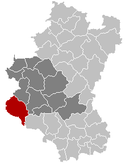
Bouillons läge i Belgien | |||
 Bouillons läge i provinsen Luxembourg | |||
| Webbplats: www.bouillon.be | |||

Bouillon (vallonska: Bouyon) är en kommun i provinsen Luxembourg i regionen Vallonien i Belgien. Bouillon hade 5 357 invånare (2017).[1]
Referenser
Externa länkar
 Wikimedia Commons har media som rör Bouillon.
- Bouillons officiella webbplats
Media som används på denna webbplats
The civil ensign and flag of Belgium. It is identical to Image:Flag of Belgium.svg except that it has a 2:3 ratio, instead of 13:15.
Shiny red button/marker widget. Used to mark the location of something such as a tourist attraction.
*Coat of arms of the city of Bouillon, Belgium.
*Coat of arms of the former municipality of Frasnes-lez-Gosselies, Belgium.
Författare/Upphovsman: Jean-Pol GRANDMONT, Licens: CC BY 3.0
Bouillon (Belgium): the Semois river, the city and the fortified castle (10th–16th centuries).
Författare/Upphovsman: Bert Kaufmann from Roermond, Netherlands, Licens: CC BY-SA 2.0
Panorama of Bouillon, Belgium.
Författare/Upphovsman: NordNordWest, Licens: CC BY-SA 3.0
Location map of Belgium


