Bognes
| Bognes | |
| Ort | |
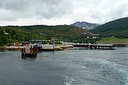
Färjeläget i Bognes. | |
| Land | |
|---|---|
| Fylke | Nordland fylke |
| Kommun | Hamarøy |
| Höjdläge | 1 m ö.h. |
| Koordinater | 68°13′29″N 16°4′32″Ö / 68.22472°N 16.07556°Ö |
| Tidszon | CET (UTC+1) |
| - sommartid | CEST (UTC+2) |
| Geonames | 3160836 |
(c) Karte: NordNordWest, Lizenz: Creative Commons by-sa-3.0 de Ortens läge i Nordland fylke | |
(c) Karte: NordNordWest, Lizenz: Creative Commons by-sa-3.0 de Nordland fylke i Norge | |
| Wikimedia Commons: Bognes ferry terminal | |
Redigera Wikidata | |
Bognes (lulesamiska: Bognássje) är en mindre by i Hamarøy kommun i Nordland fylke i norra Norge. Byn ligger där Europaväg 6 möter riksväg 85, på västra sidan av Tysfjorden. Den har färjeförbindelse både med byn Skarberget på andra sidan Tysfjorden (Europaväg 6) samt med tätorten Lødingen på andra sidan Vestfjorden (Riksväg 85).[1]
Referenser
Media som används på denna webbplats
Författare/Upphovsman: Gutten på Hemsen, Licens: CC0
Flag of Norway with colors from the previous version on Commons. This file is used to discuss the colors of the Norwegian flag.
Shiny red button/marker widget. Used to mark the location of something such as a tourist attraction.
(c) Karte: NordNordWest, Lizenz: Creative Commons by-sa-3.0 de
Location of county Nordland in Norway (2024)
Författare/Upphovsman: TorbjørnS, Licens: CC BY-SA 3.0
Bognes in Tysfjord, Norway. Europe Ferrycrossing at E6 and from E6 to E10.
(c) Karte: NordNordWest, Lizenz: Creative Commons by-sa-3.0 de
Location map of Nordland, Norway


