Boffres
| Boffres | |
| Kommun | |
 | |
| Land | |
|---|---|
| Region | Auvergne-Rhône-Alpes |
| Departement | |
| Arrondissement | Tournon-sur-Rhône |
| Kanton | Vernoux-en-Vivarais |
| Koordinater | 44°55′N 4°42′Ö / 44.917°N 4.700°Ö |
| Yta | 30,1 km²[1] |
| Folkmängd | 618 ()[2] |
| Befolkningstäthet | 21 invånare/km² |
| Tidszon | CET (UTC+1) |
| - sommartid | CEST (UTC+2) |
| Postnummer | 07440 |
| INSEE | 07035 |
| Geonames | 6446744 |
| OSM-karta | 1634923 |
 Kommunens läge i regionen Auvergne-Rhône-Alpes i Frankrike. | |
| Webbplats: http://www.boffres.fr | |

Boffres är en kommun i departementet Ardèche i regionen Auvergne-Rhône-Alpes i sydöstra Frankrike. Kommunen ligger i kantonen Vernoux-en-Vivarais som ligger i arrondissementet Tournon-sur-Rhône. År 2022 hade Boffres 618 invånare.
Befolkningsutveckling
Antalet invånare i kommunen Boffres
Referens: INSEE[3]
Galleri
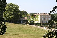
 Château Perier
 Château des Faugs
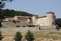 Château de Cachard
Se även
Källor
- ^ Répertoire géographique des communes, Institut national de l'information géographique et forestière, läst: 26 oktober 2015.[källa från Wikidata]
- ^ Populations de référence 2022, Institut National de la Statistique et des Études Économiques, 19 december 2024.[källa från Wikidata]
- ^ Chiffres clés - Évolution et structure de la population Arkiverad 5 juli 2012 hämtat från the Wayback Machine.
Media som används på denna webbplats


Blason de l'ancien pays du Vivarais (Languedoc) : d'azur semé de fleurs de lys d'or à la bordure du même chargée de huit écussons aussi d'azur
Författare/Upphovsman: Eric Gaba (Sting - fr:Sting), Licens: CC BY-SA 4.0
Blank physical map of metropolitan France for geo-location purpose.
Scale : 1:14 816 000 (accuracy : about 3,7 km) for the bathymetry. More maps of France, view → Commons Atlas of France.

Shiny red button/marker widget. Used to mark the location of something such as a tourist attraction.
Författare/Upphovsman: Charcutaille, Licens: CC BY-SA 3.0
The village of Boffres


Författare/Upphovsman:
|
Map data (c) OpenStreetMap contributors, CC-BY-SA _French_municipality_map.svg) • Shape files infrastructure: railway, highways, water: all originally by OpenStreetMap contributors. Status december 2011 *note: shown commune boundaries are from OSM dump May 2012; at that time about 90% complete |
Map commune FR insee code 07035.png