Blytheville
| Blytheville | |
| city | |
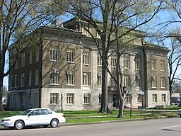
Mississippi Countys domstolsbyggnad i Blytheville. | |
| Land | |
|---|---|
| Delstat | Arkansas |
| County | Mississippi County |
| Höjdläge | 78 m ö.h. |
| Koordinater | 35°55′57″N 89°54′18″V / 35.93250°N 89.90500°V |
| Yta | 54 km² (2010)[1] |
| - land | 53,8 km² |
| - vatten | 0,2 km² |
| Folkmängd | 15 620 (2010)[2] |
| Befolkningstäthet | 290 invånare/km² |
| Tidszon | CST (UTC-6) |
| - sommartid | CDT (UTC-5) |
| ZIP-kod | 72315[3] |
| FIPS | 0507330 |
| Geonames | 4102412 |
Ortens läge i Arkansas | |
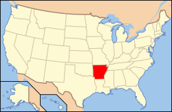
Arkansas läge i USA | |
Blytheville är en stad (city) i Mississippi County i delstaten Arkansas, USA. Blytheville är administrativ huvudort (county seat) i Mississippi County.
Källor
- ^ ”2010 Census Gazetteer Files”. US Census Bureau. Arkiverad från originalet den 14 juli 2012. https://www.webcitation.org/699nOulzi?url=http://www.census.gov/geo/www/gazetteer/files/Gaz_places_national.txt. Läst 14 juli 2012.
- ^ ”Blytheville (city), Arkansas” (på engelska). State & County Quickfacts. U.S. Census Bureau,. Arkiverad från originalet den 12 juni 2012. https://www.webcitation.org/68MhcaZmT?url=http://quickfacts.census.gov/qfd/states/05/0507330.html. Läst 12 juni 2012.
- ^ ”2010 ZIP Code Tabulation Area (ZCTA) Relationship Files”. U.S. Census Bureau. 30 augusti 2010. Arkiverad från originalet den 25 augusti 2012. https://www.webcitation.org/6ABdwXxbq?url=http://www.census.gov/geo/www/2010census/zcta_rel/zcta_place_rel_10.txt. Läst 25 augusti 2012.
Media som används på denna webbplats
Shiny red button/marker widget. Used to mark the location of something such as a tourist attraction.
Författare/Upphovsman: Alexrk2, Licens: CC BY 3.0
Den här Det karta skapades med GeoTools.
Front and western side of the Mississippi County Courthouse, located at 200 W. Walnut Street in Blytheville, Arkansas, United States. Built in 1919, it is listed on the National Register of Historic Places.
Författare/Upphovsman: Huebi, Licens: CC BY 2.0
Map of USA with Arkansas highlighted


