Bluefield, West Virginia
| Bluefield | |
| city | |
West Virginian Hotel | |
| Land | |
|---|---|
| Delstat | West Virginia |
| County | Mercer County |
| Höjdläge | 796 m ö.h. |
| Koordinater | 37°16′11″N 81°13′20″V / 37.26972°N 81.22222°V |
| Yta | 23,4 km² (2010) |
| - land | 23,4 km² |
| - vatten | 0,0 km² |
| Folkmängd | 10 447 (2010) |
| Befolkningstäthet | 446 invånare/km² |
| Tidszon | EST (UTC-5) |
| - sommartid | EDT (UTC-4) |
| ZIP-kod | 24701 |
| Riktnummer | 304/681 |
| FIPS | 5408524 |
| Geonames | 4799622 |
Ortens läge i West Virginia | |
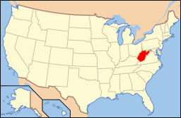
West Virginias läge i USA | |
| Webbplats: https://www.cityofbluefield.com/ | |
Bluefield är en stad i Mercer County i West Virginia i USA.[1] Vid 2010 års folkräkning hade Bluefield 10 447 invånare.[2]
Kända personer från Bluefield
- Charlie Barnett, skådespelare
- John Forbes Nash, matematiker
- Norman I. Platnick, araknolog
Källor
- ^ Bluefield, West Virginia. City Data. Läst 24 juli 2022.
- ^ Bluefield, West Virginia. Roadside Thoughts. Läst 24 juli 2022.
|
Media som används på denna webbplats
Shiny red button/marker widget. Used to mark the location of something such as a tourist attraction.
Författare/Upphovsman: This version: uploader
Base versions this one is derived from: originally created by en:User:Wapcaplet, Licens: CC BY 2.0
Map of USA with West Virginia highlighted
Författare/Upphovsman: Alexrk2, Licens: CC BY 3.0
Location map of West Virginia, USA
Equirectangular projection, N/S stretching 130.0 %. Geographic limits of the map:
- N: 40.8° N
- S: 37.0° N
- W: 82.8° W
- E: 77.5° W
Författare/Upphovsman: MarkMcCain, Licens: CC BY-SA 4.0
Photo of the West Virginian Hotel in downtown Blufield, West Virginia.


