Bloomfield, Kentucky
| Bloomfield | |
| Stad (city) | |
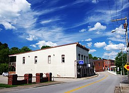
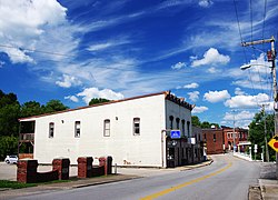
Väg genom Bloomfield | |
| Land | |
|---|---|
| Delstat | |
| County | Nelson County |
| Höjdläge | 206 m ö.h. |
| Koordinater | 37°54′52″N 85°19′9″V / 37.91444°N 85.31917°V |
| Area | 3,79 km² (2020)[1] |
| - land | 3,73 km² (2020) |
| - vatten | 0,06 km² (2020) |
| Folkmängd | 961 (2020)[2][3] |
| Befolkningstäthet | 257 invånare/km² |
| Grundad | 1819 |
| Tidszon | EST (UTC-5) |
| - sommartid | EDT (UTC-4) |
| ZIP-kod | 40008 |
| Riktnummer | 502 |
| GNIS-kod | 487497 |
| Geonames | 4284890 |
Bloomfield i Nelson County och Kentucky | |
Kentuckys läge i USA | |
| Wikimedia Commons: Bloomfield, Kentucky | |
| Webbplats: http://www.bloomfieldky.com | |
| Redigera Wikidata | |
Bloomfield är en ort (city) i Nelson County i delstaten Kentucky i USA. Orten hade 961 invånare, på en yta av 3,79 km² (2020).[4][5]
Referenser
- ^ Gazetteer Files – 2020 (på engelska), United States Census Bureau, läs online, läst: 9 november 2021.[källa från Wikidata]
- ^ Explore Census Data – Bloomfield city, Kentucky (på engelska), United States Census Bureau, läs online, läst: 9 november 2021.[källa från Wikidata]
- ^ United States Census Bureau (red.), USA:s folkräkning 2020, läs online, läst: 1 januari 2022.[källa från Wikidata]
- ^ ”Explore Census Data – Bloomfield city, Kentucky” (på engelska). United States Census Bureau. https://data.census.gov/cedsci/profile?g=1600000US2107516. Läst 9 november 2021.
- ^ ”Gazetteer Files – 2020” (på engelska). United States Census Bureau. https://www.census.gov/geographies/reference-files/time-series/geo/gazetteer-files.2020.html. Läst 9 november 2021.
Externa länkar
 Wikimedia Commons har media som rör Bloomfield.
Media som används på denna webbplats
Författare/Upphovsman: Brian Stansberry, Licens: CC BY 4.0
Kentucky Route 48 (Fairfield Hill Road) in Bloomfield, Kentucky, United States. The Medica Pharmacy and Bloomfield Barbershop occupy the building on the left.
(c) DemocraticLuntz på engelska Wikipedia, CC BY-SA 4.0
Location of Bloomfield in Nelson County, Kentucky.
FIPS code: 21-07516
Own work, based on concept by Arkyan, using Census Bureau Tiger GIS data and a custom fork of Kartography adapted for this purpose, available atFörfattare/Upphovsman: This version: uploader
Base versions this one is derived from: originally created by en:User:Wapcaplet, Licens: CC BY 2.0
Map of USA with Kentucky highlighted


