Blaye
| Blaye | ||
| Kommun | ||
 | ||
| ||
| Land | ||
|---|---|---|
| Region | Nouvelle-Aquitaine | |
| Departement | ||
| Arrondissement | Blaye | |
| Kanton | Blaye | |
| Koordinater | 45°7′N 0°39′V / 45.117°N 0.650°V | |
| Yta | 6,42 km²[1] | |
| Folkmängd | 4 957 ()[2] | |
| Befolkningstäthet | 772 invånare/km² | |
| Tidszon | CET (UTC+1) | |
| - sommartid | CEST (UTC+2) | |
| Postnummer | 33390 | |
| INSEE | 33058 | |
| Geonames | 2967108 | |
| OSM-karta | 1664257 | |
 Kommunens läge i regionen Nouvelle-Aquitaine i Frankrike | ||
| Webbplats: http://www.blaye.fr | ||


Blaye är en stad i departementet Gironde i regionen Nouvelle-Aquitaine i Frankrike. År 2021 hade Blaye 4 957 invånare. Blaye ligger högra banken av Girondeestuariet och 55 km norr om Bordeaux.
Enligt legenden är hjälten Roland begravd i stadens basilica. Carolina av Bägge Sicilierna satt fängslad i staden mellan 1832 och 1833.
Staden hette tidigare Blaye-et-Sainte-Luce och namngavs Blaye i juni 1961.
Befolkningsutveckling
Antalet invånare i kommunen Blaye
Referens:INSEE[3]
Galleri
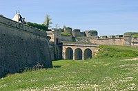 Citadellet
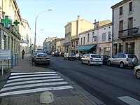
Se även
Källor
- ^ Répertoire géographique des communes, Institut national de l'information géographique et forestière, läst: 26 oktober 2015.[källa från Wikidata]
- ^ Populations légales 2021, Institut National de la Statistique et des Études Économiques, 28 december 2023.[källa från Wikidata]
- ^ Chiffres clés - Évolution et structure de la population Arkiverad 5 juli 2012 hämtat från the Wayback Machine.
Externa länkar
 Wikimedia Commons har media som rör Blaye.
Media som används på denna webbplats

Författare/Upphovsman: Eric Gaba (Sting - fr:Sting), Licens: CC BY-SA 4.0
Blank physical map of metropolitan France for geo-location purpose.
Scale : 1:14 816 000 (accuracy : about 3,7 km) for the bathymetry. More maps of France, view → Commons Atlas of France.

Shiny red button/marker widget. Used to mark the location of something such as a tourist attraction.

.svg)
Författare/Upphovsman: Zorlot, Licens: CC BY-SA 4.0
Blason Blaye (Gironde) :D'azur à la porte de gueules coulissée de sable, fortifiée de deux tours, le tout d'argent maçonné aussi de sable, surmonté d'une fleur de lys d'or et posé sur une rivière ondée aussi d'argent mouvant de la pointe.


Författare/Upphovsman:
|
Map data (c) OpenStreetMap contributors, CC-BY-SA _French_municipality_map.svg) • Shape files infrastructure: railway, highways, water: all originally by OpenStreetMap contributors. Status december 2011 *note: shown commune boundaries are from OSM dump May 2012; at that time about 90% complete |
Map commune FR insee code 33058.png
Författare/Upphovsman: Cobber17, Licens: CC BY-SA 3.0
Une autre vue sur Blaye, Aquitaine, Gironde, France