Blackmore
| Blackmore | |
| Land | |
|---|---|
| Riksdel | England |
| Region | Östra England |
| Ceremoniellt grevskap | Essex |
| Administrativt grevskap | Essex |
| Distrikt | Brentwood |
| Koordinater | 51°41′21″N 0°19′25″Ö / 51.689207°N 0.323488°Ö |
| Area | 0,258 km² |
| Folkmängd | 822 (2015) |
| Befolkningstäthet | 3 186 invånare/km² |
| Tidszon | UTC (UTC+0) |
| - sommartid | BST (UTC+1) |
| Geonames | 2655466 |
Läge i Storbritannien | |
Blackmore är en by i Essex i England. Byn är belägen 11,9 km från Chelmsford.[1] Orten har 822 invånare (2015).[2]
Referenser
- ”BLACKMORE”. GENUKI. http://www.genuki.org.uk/cgi-bin/maplink?CCC=ESS,GR=TL607015,PLACE=BLACKMORE. Läst 26 juli 2017.
- ^ ”Distance from BLACKMORE [TL607015”]. GENUKI. http://www.genuki.org.uk/cgi-bin/howfar?CCC=ESS,FROMGR=TL607015,FROMPN=BLACKMORE. Läst 26 juli 2017.
- ^ ”Blackmore”. City Population. http://www.citypopulation.de/php/uk-england-eastofengland.php?cityid=E34003787. Läst 26 juli 2017.
Media som används på denna webbplats
Författare/Upphovsman: Alexrk2, Licens: CC BY-SA 3.0
Location map of the United Kingdom
Shiny red button/marker widget. Used to mark the location of something such as a tourist attraction.
Författare/Upphovsman: Acabashi, Licens: CC BY-SA 4.0
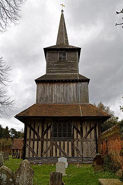
From the west of the churchyard looking towards the tower of the 12th-century Grade I listed parish church of St Laurence, previously a priory church, at Blackmore, Essex, England.
Camera: Canon EOS 6D with Canon EF 24-105mm F4L IS USM lens.
Software: large RAW file lens-corrected, optimized and downsized with DxO OpticsPro 10 Elite, Viewpoint 2, and Adobe Photoshop CS2.


